![]()
MONTHLY AND SEASONAL REPORTS ON THE WEATHER DURING 2004 FROM BRADNINCH (Weather records started in 1990)
( See also charts by month from statistics main page)
Occasionally there might be links from this page to other pages especially if there is any severe or unusual weather like thunderstorms or any charts of interest, ect. All links will be in blue and don't forget to use the back button on your browser to return to this page.
REPORTS BY MONTH= Jan, Feb, Mar, Apr, May, Jun, Jul, Aug, Sep, Oct, Nov, Dec.
REPORTS BY SEASON= Winter, Spring, Summer, Autumn.
JANUARY
The month started on a quiet note with high pressure and it remained foggy all day on the 4th. From the 6th it became more mobile from the Atlantic with fronts crossing the country. The 8th saw a very active cold front move across the country bringing the wettest day since the 15th October 2002 with 27.8MM. Storm force winds were predicted for the south of the UK on the 12th but this didn't come as the low tracked further south into France, however we did get 16.4MM of rain on the day. The weather remained very mobile to the 16th with more rain bands. A quieter spell from the 17th to the 21st as high pressure moved in. A small low moved across the south on the 22nd with 7.6MM falling. Westerlies to the 25th the a change as colder air from the Artic started to move south. This cold air arrived here in Devon after the clearance of a cold front that brought a snow shower on the 28th. A very cold night followed with -4.4C by 9am on the 29th. Milder air moved up from the south west on the 30th and a stormy spell ended the month with severe gales. I witnessed a large tree come down in this storm.
Rainfall for the month was 122.6mm and this was +38.5mm from the 10 year average. It was a very mild January. Temperatures were:- 9.2C (+1.3 From average), Min 3.4 (+.7C) and a mean of 6.3C (+1C).
OVERALL A MILD, WET MONTH
FEBRUARY
The 1st saw the wettest day since the 8th August 1999 with a huge 35.4MM falling on the day. During the afternoon there was a severe rainstorm giving 23.8MM in 3 hours with 15MM of that falling in just half an hour. Flooding occurred on every road as torrents flowed of fields onto them, and many got closed like the B3181 at Westcott. This was the worst localised flooding I’ve witnessed since the severe flooding of the 7th August 1997 thunderstorm. The 2nd saw a warm front move northwards and this resulted in some unusually high temperatures as the air source was from the Azores. The 3rd had the highest minimum for February since records began with 12.3C (9.5C above the average). From the 29th January the minimum had climbed by 16.7C to the 3rd February (see chart below). The 4th was another record breaker, as we experienced the highest maximum for February on record with a dizzy high of 15.7C. London was warmer on the 4th with an amazing 18C making this the warmest day here on record too. Never before can I remember such an interesting temperature pattern for February. waving cold front that had affected Wales and the north Midlands bringing over 400MM in 3 days gradually moved south to clear the south coast on the 6th. Pressure started to build from the south west to bring a long settled spell. Temperatures dropped daily with a minimum of minus 3.8C on the 9th. Pressure climbed to 1036.5MB on the 9th as the whole country was under the influence of this high. There was a lot of cloud trapped in the high and with calm conditions the cloud hanged around on the 12th and 13th. A weak cold front moved south on the 17th and a much clearer, sunnier high followed to maintain settled conditions to the 24th. It turned very cold as a northerly wind set in and snow fell over most of the country during the last 5 days of the month. Heavy snow and hail showers fell over Bradninch on the 26th and early on the 27th. It has been very dry since the 9th to the 29th with only 4.2MM falling.
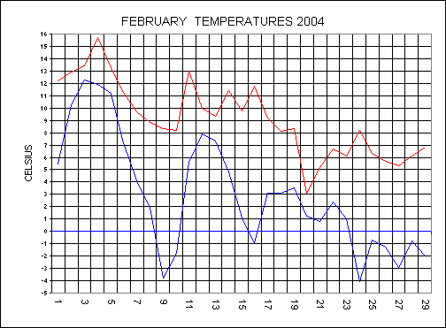
Rainfall for the month was 72.2mm and this was +13.2mm from the 10 year average. Temperatures were:- 9.1C (+0.4 From average), Min 3.0 (+.2C) and a mean of 6.0C (+.2C).
EXCEPTIONALLY MILD START AND COLD END
WINTER SUMMARY (Dec 2003- Feb 2004)
Rainfall for the Winter was 267.4MM and this was near the average of 249.5MM.
Temperatures were also close to the average with a Maximum of 9C (+.7C), Min 3.3 (+.2C) and the mean was 6.2C (+.5C)
MARCH
High pressure over the country on the 1st and 2nd gave 2 very cold nights with minus 2.7C on the 1st and minus 6.2C on the 2nd. The 2nd therefore had the lowest Minimum temperature for March since records began. The last 2 years have had the lowest temperature of the year during March. Late frosts do seem to be coming more common, making up for a decrease in the early Winter (Dec) ones. Weak fronts moved across relatively still high pressure from the 3rd to the 5th bringing a total of 2.4MM for the period. Pressure increased to 1036MB by the 8th as we settled into a spell of fine weather. From the 8th February to the 10th March rainfall was very low with only 7.2MM falling. The high gradually moved into Scandinavia and this resulted in an air- stream coming off a cold Continent by the 10th. An occluded front started to move into the west on the 11th and as this moved over very cold air any rainfall turned to snow. Most of the country had a fall of snow including us here at Bradninch during the evening and night of the 11th. The 11th also had gales and with a high of only 4.7C it felt more like minus 14C with the wind chill. From the 12th active Atlantic weather systems moved in, to bring rain and much milder weather. The 12th and 13th saw 24.8MM falling and the ground was back to a wet state again. A warm front moved up from the south on the 15th and this produced some very high temperatures to parts of country. The 16th saw temperatures of 17-18C across parts of the Midlands and we here had a high of 15.1C. Deep depressions moved across the country on the 19th and 20th bringing heavy rain and gales but it did remain mild. From the 22nd showers moved down from the north with thunder and hail on the 23rd. High pressure moved across at the end of the month and this introduced a warm southerly flow with 16.8C on the 30th.
Temperatures were lower than the average with:- Max 11C (-.2C), Min 3.6C (-.8C) and the Mean was 7.3C (-.5C). Rainfall was slightly below the average of 55.2MM with 46.4MM falling during the month.
APRIL
A southerly flow started the month with a high of 13.9C on the 1st despite the cloudy skies. A series of fronts crossed the country from the south west from the 2nd to the 4th with the final cold front on the 4th bringing 10.4MM. A complete change in the air-flow from the 6th as we were under a cool northerly flow and the temperatures dropped. The 6th and 7th had April showers some with hail and it felt very cold in the strong winds. The last air frost of the Spring came on the 8th with a low of minus 0.6C. Pressure started to build from the 9th and despite some weak fronts it remained settled over the Easter weekend although rather cloudy. The high gradually pulled away eastwards from the 13th to allow Atlantic fronts back in again. A cold front moved erratically across the country on the 16th and 17th, traveling at only 6.4KM per hour at times in an eastwards direction. A more active frontal system swept across the whole country overnight on the 17th and heavy showers followed. Pressure dropped from 1027.1MB on the 12th to 980.1MB on the 18th, that’s a 47MB drop in 6 days. It remained very unsettled to the 22nd with a prolonged spell of rain on the 21st bringing 8.2MM. Warmer more settled weather moved in from the 22nd and we all enjoyed a warm weekend on the 24th/25th. By the 26th the maximum climbed to 21.9C. However, this warm spell didn't last as a low tracked up from France to bring a very unsettled spell of weather to end the month. The maximum temperature dropped by 11.7C from the 26th to the 29th (see chart below) with a high of only 10.2C on the 29th. It felt more like Winter on the 29th with a cold north easterly wind and cloudy skies bringing 11MM.
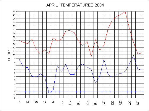
Temperatures were slightly above the average with:- Max 14.3C (+1C), Min 5.3C (0C) and the Mean was 9.8C (+.5C). Rainfall was slightly below the average with 65MM falling compared to the average of 84.6MM.
MAY
Mostly fine on the 1st and 2nd with light winds and a high of 19.7C on the 2nd. A low moved out of Greenland on the 2nd and by the 4th it had developed remarkable to a record low pressure for May of 978.6MB, that’s a drop of 29.2MB in 48 hours. The 4th had gales with 8.2MM falling and it felt cold with a high of only 12.7C. The 5th and 6th saw the low remain over the country bringing showers and it remained chilly. A ridge of high pressure on the 7th gave the last ground frost of season with an air temperature of 1.2C. Another low affected the east on the 8th and 9th but here in the south west it was mostly dry although rather cloudy at times. However, the south west saw the most dramatic weather of the whole country on the 10th and 11th as we were in an area of slack pressure where anything can happen. During the afternoon of the 10th a thunderstorm developed over the Thorverton area. New Cumulonimbus cells grew over Stoke cannon (where I was) and we had a deluge in such a short time - just like a tap being turned on. This storm only affected a small area, as I cycled to Pinhoe it was completely dry just 1.5 miles away. The 11th was the perfect day for development of storms. It soon warmed up over the land with a humid 22.6C. A prevailing northerly breeze met the cooler sea breeze from the south and a convergence zone was set-up from Honiton to Crediton. A convergence zone is were two air masses collide and forces the air to rise rapidly into the upper atmosphere. As a result, with warmer air rising into cold upper air, convection soon takes place and storms grow rapidly into Cumulonimbus clouds to 40,000ft (12KM). This situation locally is fairly rare, combined with the right slack pressure we had at the time. By 12:30 on the 11th a storm developed over Honiton and new cells again grew in this convergence zone over Killerton. With two winds meeting in opposite directions you sometimes get funnel clouds and this was what I witnessed form over Killerton. A funnel cloud was spinning down and I captured it on video and photographed it (Photo below). This was only the 2nd funnel cloud I’ve witnessed even though it only lasted 10 minutes. A severe burst of rainfall fell from this storm and a field of newly planted maize completely washed into the road near Danes woods. The road was under 2 feet of silt and water. Again this storm was very localised as Bradninch was dry as we remained in the dry zone. This same said storm apparently produced another funnel cloud that touched the ground, therefore it became a tornado somewhere over the moors towards Okehampton. Pressure started to build from the 12th to bring a very fine settled spell to the 28th and it remained dry throughout this period. Both the temperature and pressure rose daily to 24.5C on the 17th as we had very sunny conditions. An unsettled end to the month with An Atlantic low moving across the south on the 31st.
Temperatures were average with:- Max 18.8C (+1.2C), Min 7.0C (-1.1C) and the Mean was 12.9C (0.0C). Rainfall was below the average with 30.8MM falling compared to the average of 55.1MM.
FUNNEL CLOUD

Killerton is the clump (hill) between the two trees right. Bradninch bottom left.
SPRING SUMMARY (March-May)
Rainfall for the Spring was 142.2.4MM and this was well below the average of 194.8MM.
Temperatures were close to the average with a Maximum of 14.7C (+.7C), Min 5.3 (-.7C) and the mean was 10C (0.0C)
JUNE
High
pressure has dominated the scene up to the 21st here in the South
West bringing a lot of settled weather. The first week saw the Azores high push
up, and when this settled down over the Continent we had a hot southerly flow,
with a high maximum of 27.2C on the 7th. The maximum in London topped
31C by the 8th. The hot high got moved on by a very weak cold front
that crossed the country on the 9th and we then had lower
temperatures. Another high established itself over the country from the 11th
and day by day the temperature climbed again. Visibility in this high was
fanatically clear as the air was very dry with a low humidity of 35% during the
afternoon of the 16th. With unbroken sunshine on the 15th
and 16th the temperature soared back up to 27.2C. The 17th
was a total change as a weak cold front introduced a cooler northerly flow.
There was a drop of 9.2C from the 16th to the 17th, with a
high of only 18C on the 17th. From the 18th to the 21st
we remained in this air stream with showers affecting the east of England but it
stayed dry here in the South West. Rain has not featured so far this month as
there has been very little indeed. Rainfall for June to the 21st has
only totaled 4.6MM and since the 7th
May to the 21st June (46 days) we have only had 17.8MM. Rain has
fallen on only 7 days of these 46, which means we have had 39 dry days in the last 46, what a statistic. Although we are
experiencing drought conditions, in meteorological terms a drought gets issued
after 21 days with no rainfall. As we had sporadic rainfall over these 46
days, it is not a true drought, a bit bizarre when everything is turning brown.
This has certainly been the 2nd longest dry spell in June since 1990.
The driest June on record was during 1995 when we only had a total of 6MM for
the whole month. It would have been great to have beaten this during this June
but the 22nd changed all this as we had the first good rainfall for 7
weeks. The 22nd was the wettest day since the 1st February
with a total of 23.4MM falling during a very miserable day. The low that brought
all the rain deepened further on the 23rd to give SEVERE GALES across
Devon and many large branches came down. This was the windiest June day on
record.
Temperatures were : Max 21.4C (+1.5C), Min 10.6C (-.1C) and the Mean was 16C (+.7C). Rainfall was slightly below the average with 47MM falling compared to the average of 62.1MM.
JULY
This July has been very unsettled due to the Jet-Stream being much further south than usual. The 7th saw another very unusually deep low moving up from the south giving SEVERE GALES and driving rain. The first week of the month had 33.8MM falling during a miserable week. The 9th saw the low move north east and slightly drier air moved in but still cloudy at times. The 12th and 13th saw a ridge of high pressure and this lifted the temperature to 22.6C on the 13th. From the 14th to the 17th we here in the south were under a warm sector as a waving front lied across the middle of the country. Stubborn status clouds only burnt away late in the day, but when it did the temperatures jumped to 24.4C during the afternoon of the 15th. The nights were warm with a minimum on the 16th of 16.1C. The cold front finally moved across the whole country on the 17th to give much fresher, clearer air with more sunshine. High pressure moved in from the west on the 23rd and this gave the first good weekend's weather of the month on the 24th and 25th. The end of the month was very warm with 27.2C on the 31st.
Temperatures were below average due to the lack of sunshine during the month. They were Max 21.4C (-.3C), Min 11C (-1.9C) and the mean worked out at 16.3C (-1C).
Rainfall was very close to the average with 50.6MM falling making this +4.7MM above the average.
AUGUST
The first week of the month was very dry with the highest minimum for 9 years coming on the 8th with a minimum of 18.7C. The 12th saw the breakdown as we had the first heavy rainfall for weeks with 19.2MM. It remained unsettled and on the 16th Boscastle was Severely flooded while we here only had 6.6MM. The Boscastle area had around 175MM in a 5 hour period (Nearly our total rainfall for the whole Summer here in Bradninch). Low pressure was then in control to the 27th bringing a lot of cloudy days with chilly conditions. High pressure finally returned to end the month.
Temperatures were near .5C near to the average with a Maximum of 22.2C (+.7C), Minimum 12.7C (-.3C) and the Mean was 17.5C and this was +.4C above the long term average.
Rainfall was slightly above average with 84MM (+5.6MM). It was the 4th wettest August since 1990.
OVERALL A DISAPPOINTING MONTH
SUMMER SUMMARY
June and July were both average months with some good sunshine and conditions were very dry. August was the bad month of the three.
Bradninch missed out on all the flooding and we ended up the Summer with having 181.6MM of rainfall and this was minus 4.6MM from the average of 186.2MM.
Temperatures were: Maximum 21.1C (+1.1C), Minimum 11.4C (-.8C) and the Mean was 16.3C (-.1C).
SEPTEMBER
The first week of the month saw high pressure bringing back some very good Summer weather. The maximum temperature climbed daily to a record high for September on the 5th with a staggering 28.5C. This was also the joint hottest day of the year with the 5th August. The 5th and 6th had unbroken sunshine but there was a refreshing north easterly breeze of 25mph on the 6th. The high gradually moved away eastwards after another hot, fine day on the 9th. A breakdown moved in from the south west as a low moved in, and this first produced isolated thunderstorms to break out. We had a power cut at 06:11 on the 10th as a one strike wonder hit the power lines near Cullompton. A series of Atlantic weather systems then started to move across the whole country bringing Autumnal winds and rain. The 13th and 14th had a total of 17.6MM falling as cold fronts moved south. From the 15th to the 30th most of the rain stayed in the north, while we here in the south had higher pressure.
This September has been a warm one with temperatures of: Maximum 19.9C (+1.9C), Minimum 11 (+.2C) and the mean was 15.4C (+1C).
Rainfall for the 4th year in a row has been on the low side for September with only 32MM and this was minus 53.4MM from the average. Wells levels are still at record low levels in Bradninch.
OCTOBER
Low pressure moved in off the Atlantic and stayed over the British Isles for the first week of the month bringing a total of 20.8MM over this period. A ridge of high pressure toppled across the Country on the 8th but this didn’t last as a low moved up from France. As the low moved in against the high it caused a squeeze, and gales from the north east affected the south on the 9th. The maximum only reached 12.9C on the 9th but it felt more like minus 5C taking the wind chill into account. This low gradually pulled away northwards over the next few days but another one moved in from the west on the 13th. Pressure fell to 997.4MB, and a total of 9.8MM fell on the 14th. Overnight on the 15th winds fell light here in the South West as we were in the centre of the low. The minimum dropped to 0.9C at 7.48am on the 16th making this the 3rd ground frost of the month so far. Another ridge of high pressure gave a fine day on the 17th but it didn’t last as fronts moved in from the south west to maintain the unsettled month. Total rainfall to the 20th is 56.4MM compared to only 4.6MM for the same period last year. A very unsettled end to the month with 23.6MM falling on the 29th. There was 9 days with gales during the month and only 4 dry days. The well level at Crofthayes was at a record low level at the end of the month.
Temperatures were: Max 14.6C (+.7C), Min 7.3C (-.4C) and the mean was 10.9C (+.1C). Rainfall was 126.2MM and this was +32.4MM from the average of 93.8MM.
NOVEMBER
After the unsettled weather in October this month has seen high pressure dominating. Only weak fronts have moved across the country, bringing a total of 10MM to the 15th. The 12th had a maximum of 14.1C but the next day saw only 8.7C due to a cold front that moved down from the north. The first air frost of the Autumn came on the 13th with a low of minus 0.6C. The 13th had unbroken sunshine and pressure continued to climb to 1037.5MB. A cold front moved down from the north to give a colder blast with a low of 7.2C as the max on the 20th. The 22nd saw a warm front move northwards to bring some very mild weather. The 23rd saw the highest November maximum on record with 16.3C. Pressure remained high for the remainder of the month and rainfall continued to be low.
DRIEST NOVEMBER ON RECORD WITH ONLY 33.6MM. The average for November is 103MM. Temperatures were higher than the average with: Max 12 (+1.5C), Min 5.7C (+.5C) and the mean was 8.8C (+1C).
OVERALL THE MONTH WAS QUIET AND WITH LOW RAINFALL DESPITE THERE BEING 18 DAYS WITH RAIN.
Well level at Crofthayes well is down to an all time low of only 0.5 inch (12MM)
AUTUMN
September and November were quiet months with higher pressure. The odd month was October with more rainfall.
Rainfall was well below the average again with a total of 191.8MM and this was minus 90.5MM from the average.
Temperatures overall were higher with: Max 15.5C (1.4C), Min 8C (+.1C) and the Mean was 11.7C (+.7C)
DECEMBER
The first 2 weeks of the month were fine and settled with only .4mm falling to the 15th making this the driest first 2 weeks of December on record. More mobile weather off the Atlantic to the 23rd. A cold blast from the north produced 2 cm of SNOW ON CHRISTMAS EVENING. More milder weather ended the month.
Average temps were; Max 9.4C (+1.4C from average), Min 3.4C (+.3C) and the Mean was 6.4C (+.8C). Rainfall was below average again with 76mm falling compared to the average of 106.3mm.
Temperatures were higher overall with an average maximum of 15.2C (+.9C from average), Min of 7C (-.2C) an the mean was 11.1C (+.3C).
Rainfall was some 127mm below the average of 913.4mm with only 786,4mm falling during the year.