![]()
MONTHLY AND SEASONAL REPORTS ON THE WEATHER DURING 2003 FROM BRADNINCH (Weather records started in 1990)
( See also charts by month from statistics main page)
Occasionally there might be links from this page to other pages especially if there is any severe or unusual weather like thunderstorms or any charts of interest, ect. All links will be in blue and don't forget to use the back button on your browser to return to this page.
REPORTS BY MONTH= Jan, Feb, Mar, Apr, May, Jun, Jul, Aug, Sep, Oct, Nov, Dec.
REPORTS BY SEASON= Winter, Spring, Summer, Autumn.
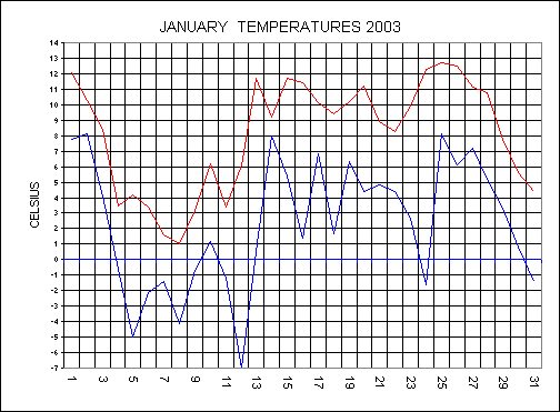
JANUARY
The
new year might have started on a mild theme with a maximum of 12.1C but this was
all change as colder air moved off the Continent. The cold spell lasted from the
2nd to the 12th during this time we had some very low
temperatures with very high wind chills. The maximum on the 7th only
reached 1.6C but it felt more like minus
17C in the wind. The evening of the 8th saw a heavy snow shower
move in from the north east to bring 2cm of snow cover, a rare sight for us now.
The morning of Sunday 12th January saw the lowest minimum for 12
years with a low of minus 7C. The cold feed from the east got cut off as the
high moved south and this brought a return to an Atlantic air stream. The
temperature chart below shows the rapid rise in the minimum temperature from the
12th. The mild, wet and windy conditions lasted to the 22nd
then there was a brief return to colder weather before more wet weather ended
the month.
Rainfall for the month was 98.6mm and this was +14.5mm from the 10 year average. It has turned out to be a cool January. Temperatures were:- 8.1C (+.2 From average), Min 2.3C (-.4C) and a mean of 5.2C (-.1C).
FEBRUARY
The 1st saw a frontal system moved across the country from the west to bring 9.2MM of rainfall during the day but it was mild with a high of 9.4C. By the 4th there was low pressure over Scandinavia and high pressure in the Atlantic and as a result the British Isles was under a cold northerly air stream. We escaped all the heavy snow that moved down from the north but parts of Dorset had 3CM and some parts of the country had 6FT drifts. A warm front moved off the Atlantic from the 6th and each day there after saw a rise in the maximum temperatures. The 7th saw a very mild day with a high for the day of 11.3C. An active cold front brought rainfall totaling 9.8MM on the 11th and this was to be the last active front to cross our area for some considerable time. High pressure built over the whole country to bring a very settled spell of weather from the 12th to the 20th. The position of the high meant that we had a flow of the cold Continent and as a result the temperature dropped here. The 15th saw a glorious day with unbroken sunshine and a high of 6.8C. With a wind of 18MPH from the north east it felt more like minus 14C at 8am on the 15th. The 16th was a very cold day with cloudy skies and a high of only 2.1C. From the 22nd high pressure built again but this time we had a southerly flow and therefore the temperatures climbed daily. A very wet day ended a relatively dry month with 14.2mm falling on the 28th.
An average rainfall month with 64.2mm and this was +5.2mm from the 10 year average. It has turned out to be the coolest February since 1996. Temperatures were:- Max 8.3C (-.4 From average), Min 2.5C (-.3C) and a mean of 5.4C (-.3C).
WINTER SUMMARY (Dec 2002- Feb 2003)
December was a mild month with temps some +1C above average. There was no air frosts during the month and this was a record breaker. December was a slightly drier month with -12.7C below the average. January was an average month but we did have the lowest minimum since 1991. Snow fell on 3 days and there was 10 air frosts. February saw 10 ground frosts and 6 air frosts.
Average Winter temperatures with both the maximum of 8.3C and the mean of 5.7C were both spot on the 10 year average. The minimum was 3.2C and this was +.1C above the average.
Rainfall was around the average with 256.4MM and this was +6.9MM above the 10 year average.
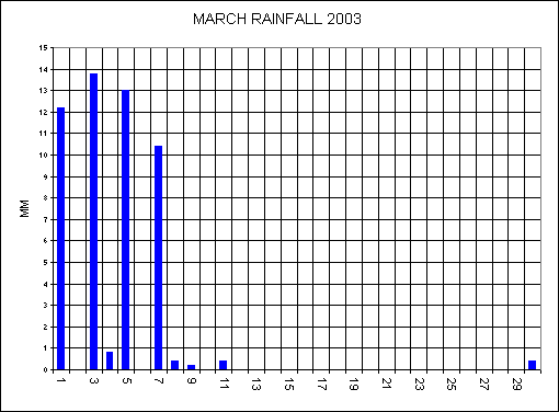
MARCH
Well,
March certainly came in like a lion this year with loud rumble of thunder at
7.16am on the 1st. This lightning knocked the power out in the whole of
Bradninch for a few seconds as it must have hit the main power line. The
rainfall was also intense with a total of 7.4MM falling in just 10 minutes,
that�s a rate of fall of 44.4MM per hour. Parts of Beacon Road and West End
Road got flooded due to the run-off from fields during this storm. A total of
52.2MM fell during a very unsettled first week to the month and this was all due
to a mild, moist, south-westerly air stream. Pressure started to build from the
11th and this dominated the weather over most of the country for the
next 20 days. Temperatures dropped slightly as we had a cool Continent flow but
it was very sunny with mostly clear blue skies. The air
became very dry as we picked up a Continental flow from
SUNNIEST MARCH ON RECORD AND THE HIGHEST AVERAGE MAXIMUM ON RECORD
AN EXCEPTIONALLY SETTLED MARCH
Another near average rainfall month with 51.6mm and this was +3.6mm from the 10 year average. Temperatures were:- Maximum 13.6C (+2.4 From average), Min 3.9C (-.5C) and a mean of 8.7C (+.9C).
APRIL
DRY AND VERY SETTLED TILL THE 24TH THEN UNSETTLED
The 1st day of the month brought 2.8MM of rain but this didn�t help the dry spell as it all evaporated up by the end of the day. High pressures over the next 3 weeks continued to bring exceptionally fine weather. The positioning of these highs made a big difference to our weather as regards to the maximum temperatures. The maximum temperatures from the 4th to the 20th were very interesting. A high of 20C on the 4th then a daily drop as the high moved north eastwards and we dragged in colder air from Scandinavia. By the 9th we had an air frost with minus 0.7C and a maximum for the day of 9.6C but it felt more like minus 10C when taking the raw, north easterly wind into account. All weather forecasters (on TV) predicted a very wet day on Sunday 13th across the south of England as a low was going to move up from the south. What happened to all this rain as we only had a light shower of 0.4MM here at Bradninch. The rain seemed to have stayed over west Devon and Cornwall and didn�t move eastwards as they predicted. The shower that we did have brought down a lot of fine, white dust in the atmosphere and all cars got covered with this by the next morning. The 14th saw a new high establish over central Europe and this brought a record breaking hot southerly air stream. From the 14th there was a daily rise in the temperature to an incredible 25.7C (click here for April max temps) by the 16th making this the hottest April day since records began by far. The previous high was 21.9C set back in 1993 but this April has smashed this high by another 3.8C. It was not all good news as we had high pollen and pollution levels as we had a flow of the Continent. The air was extremely dry with a moisture content of only 27% on the 17th making this the lowest on record as well. The drought was all over by the 25th as the first of several lows moved up across the country. A very wet end to the month and this has made up for all the dry weather over the last 7 weeks.
Below average rainfall for the month with 55.2mm and this was - 29.4mm from the 10 year average. Temperatures were:- Maximum 15.5C (+2.2 From average + 2nd highest on record), Min 4.8C (-.5C) and a mean of 10.1C (+.8C).
| RETURN TO STATISTICS INDEX |
| RETURN TO WEATHER INDEX |
MAY
The weather is certainly making up for all the dry weather during March and April with a very unsettled May (as I predicted). Low pressure was in control on the 2nd, with a vigorous little depression moving across our area, bringing gales and 12.6MM of driving rain. The May bank holiday weekend was mainly fine due to a ridge of high pressure but it was still cool and fairly cloudy. Pressure remained higher here in the south as most of the rain affected the north from the 6th to the 10th>. The 11th and 12th saw a rippling cold front affect the south bringing light patchy rain with a high of only 12.4C on the 12th. High pressure moved off the Atlantic to bring a mostly sunny day on the 14th. The fine night that followed brought a ground frost at sunrise (5am) on the 15th with an air temperature of just 0.7C. The 15th saw an occluded front move into the west and this moved across the whole country during the next 24 hours. More unsettled weather followed off the Atlantic to continue the unsettled theme until the 25th. Pressure started to build to bring some very warm settled weather to end the month. The maximum temperature climbed to 25.9C on the 30th.
Rainfall was below average of 55.1MM with 44.6MM, making this the 2nd month in a row to have below average rainfall.
The average minimum of 7C was the lowest since records began and this was minus 1.1C below the average. Maximum was 16.7C (minus .9C) and the mean turned out to be 11.8C (minus 1.1C).
OVERALL A DULL MONTH BUT DRY AND VERY WARM END
SPRING SUMMARY (March-May)
Very settled March and April with some prolonged sunshine and lots of high pressure around, rainfall was sporadic during these months. May was the opposite with a lot of dull, cool weather with lows dominating the scene. However, May was a fairly dry month.
Average Spring temperatures were: Maximum 15.2C (+1.2C above average), Minimum 5.2C (minus .8C) and the mean was 10.2C (+.2C)
Rainfall was 45.3MM below the average with 151.4MM falling during the 3 month period.
JUNE
June continued the unsettled theme with low pressure dominating bringing rain on 9 of the first 10 days of the month. Rainfall for this period totaled 31.2MM. Pressure started to build from the south from the 11th and this brought a lot of very warm, sunny weather. Thunderstorms developed in the English Channel during the early hours of the 14th, but these didn�t move inland and got swept away eastwards. The sky however at 04:00 was particularly thundery overhead with dark medium level clouds (Cast Cumulus) and crossed winds. The surface wind was from north to south and clouds were moving from south to north, a sure sign of thundery weather. Saturday the 14th started off with a temperature of 14.1C at 05:00 and this climbed to the hottest day of the year with 26.7C by 16:02. Sunday 15th was also a glorious day with a high of 26.6C under baking, bright, sunshine concluding in the best weekend of the year so far. During the evening of the 16th a thunderstorm developed in the Wellington area and lightning was visible from Bradninch. At the same time we had power cuts here, but I don�t think the power cuts were caused by the lightning as Cullompton still had power. The 17th was a much fresher day with a comfortable high of 21.9C. High pressure developed across the country from the 20th with wall to wall sunshine but it didn't last as a thundery breakdown started. Isolated storms developed inland across Devon but we escaped the storms again. A high of 26.1C on the 22nd but the next day saw only 20.6C as a cold front moved through. Another high pressure ridge moved across from the 23rd to the 26th. A deep low tracked up from the south west with the lowest pressure of the month on the 30th with 1001.2mb.
The average maximum of 21.4C was 1.5C above the average and was the highest since 1992. Minimum was minus .1C from the average with 10.6C. The mean was 16C and this was +.7C from the 10 year average.
Again for the 5th month in a row the rainfall has been around 50MM 2". Rainfall for the month was 52.6C and this was minus 5.9MM from the ave.
OVERALL A MIXED MONTH BUT WARM
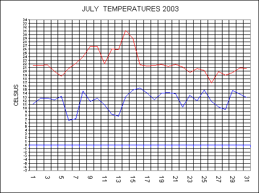
JULY
A weak low moved across the country on the 1st and 2nd with only 4.6MM falling during the 48 hour period here at Bradninch. As the low moved away the wind switched to a much fresher north westerly direction and as a result the temperatures dropped. Pressure started to build from the Azores on the 4th to bring Summer back again and the temperatures started to build to highs of 26.8C on the 9th and 10th. Scotland and the north didn�t fair so well during this period as Atlantic fronts moved across here. A cold front eventually moved down across the whole country on the 11th, and this dropped the maximum temperature by 4.8C to 22C from the day before. The 12th saw a return to very sunny weather as high pressure built once again. The maximum temperature started to soar to hot, humid conditions as we sucked in a Continental air flow. The 12th and 13th both had a maximum of 26C bringing the best weekend of the year, so far. My prediction of beating the previous hot, July day of 30.2C set back in 2001, with a July day this year was spot-on. The 14th saw the hottest day for 8 years and the hottest July day on record with a staggering 31.1C. These high temperatures and the lack of any decent rainfall for weeks have led to very dry conditions with grass turning brown and even the maize crop was wilting and shriveling up in the heat. A thundery breakdown started to move into the west from the 16th, with fresher, more comfortable conditions moving in. An unsettled end to the month with active lows moving off the Atlantic. The 25th saw the wettest day since January the 1st with 18.6MM.
Average temperatures were: Max 22.1C (+.4C from average), Minimum 12.1C (-.8C) and the mean was 17.1C (-.2C).
Rainfall for the month was 59.2MM and this was +13.3MM above the long term average.
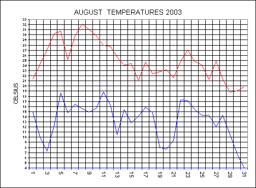
AUGUST
High pressure dominated the first 3 weeks of the month bringing some very settled weather. The 8th saw the hottest day since August 1990 with a high of 32.1C. There was a slow drop off in temperatures from the 9th but Gravesend in Kent had 38.1C on the 10th, making this the hottest day on record nationally. From the 3rd there was 11 consecutive days with temperatures in excess of 25C. The 11th had a minimum of 18.8C, making this the highest minimum for 6 years. Rainfall to the 28th was only 14.6MM and all the countryside was under drought conditions. A front moved up from the south to combine with one moving down from the north to bring the first decent rain for 4 weeks on the 29th with 11MM. A chilly end to the month with a northerly flow. The minimum on the 31st was the lowest August minimum on record with 4C.
Average maximum was 24.9C and this was 3.2C above the 10 year average and was the highest since 1995. Minimum was 13.2C and was +.3C above the average. Mean worked out to be 19C and was +1.7C above the ave.
Rainfall was only 25.6MM and this was minus 52.8MM.
SUMMER SUMMARY
Very good summer with plenty of warm sunshine. Best Summer since 1995. Poor Summer for thunderstorms with no photos or video footage.
Average Summer temperatures were: Maximum 22.8C (+1.9C above average), Minimum 11.9C (minus .3C) and the mean was 17.3C (+.9C)
Rainfall was 141MM and this was -45.2MM from the 10 year average.
SEPTEMBER
September is continuing the fine, settled weather as high pressure built from the Azores. A weak cold front moved down from the north west on the 6th and this got followed by a more active weather system on the 7th. Rain fell on the 7th and 8th with a total of 11MM for the two days. This unsettled spell didn�t last long as the Azores high reestablished itself over the country from the 12th. Summer returned as we dragged in warmer air of the Continent with some unusually high temperatures. By the 16th the maximum climbed to a record breaking high for September with 26.7C. The 17th was another very warm day with 26.4C. Fronts affected the north from the 18th to the 20th but it remained settled in the south. A cold front moved down from the north to bring much fresher weather. High pressure returned from the west from the 23rd and this brought a chilly night on the 23/24th with a low of 1.5C, giving the first ever ground frost in September since my records began. We had a record breaking low temperature on the 29th with only 1.2C.
AN INCREDIBLY DRY MONTH WITH ONLY 20.8MM, MAKING THIS THE DRIEST SEPTEMBER SINCE RECORDS BEGAN.
TEMPERATURES ALSO BROKE RECORDS WITH THE HIGHEST AVERAGE MAXIMUM SINCE RECORDS BEGAN WITH 20.7C (+2.7C from average).
THE AVERAGE MINIMUM WAS THE LOWEST SINCE RECORDS BEGAN WITH 8.4C (-2.4C).
THE MEAN WAS 14.6C (+.2C).
OVERALL THE MONTH WAS DRY AND WARM WITH 5 RECORDS BROKEN.
OCTOBER
A cloudy day greeted the month as there was a cold front in the English Channel, the rain from this front never reached mid-Devon but Cornwall had some. The 3rd had an occluded front moving down from the north west and pressure started to then build from the west. From the 4th to the 9th there was a very large high in the north Atlantic and due to the position of this high all fronts moved down from the north west over the UK. Weak fronts moved across the south west on the 6th and 7th bringing a total of 3.4MM for both days. The 10th saw pressure build over the whole country and this resulted with dense fog early on the 11th but the rest of the day was fine and sunny with a high of 18.1C. This high moved over Scandinavia and this pulled the air from the now, cooler, mainland Europe. The temperatures dropped and the cold north easterly wind picked up but it was very sunny by day. Cirrus clouds produced excellent red and orange sunsets on the 15th and 16th. With a cold air stream this resulted in a sharp frost early on the 21st, with a low of minus 2.6C. Low pressure developed across the country on the 21st, and as this moved into France it pulled in some very cold air. The 22nd was the coldest October day since 1992 with a high of only 5.6C. We actually had some good rainfall on the 22nd with 7.6MM and snow fell on Dartmoor during this very cold afternoon. I cannot remember the last time that happened in October before. The morning of the 25th had a low of -3.1C making this the lowest minimum for October since records began. A very unsettled end to the month with a drop of 50.9mb from the 27th to the 30th as a deep low brought the first significant rainfall for some time.
Average maximum was 14.1 and this was .2C above the 10 year average. Minimum was 5.8C and was -1.9C below the average. Mean worked out to be 9.9C and was -.9C below the ave.
Rainfall was only 55.6MM and this was minus 38.2MM.
THE
DROUGHT OF 2003: The
drought conditions have continued from the Summer now well into the Autumn with
the ground state being exceptionally dry. Rainfall for this year Jan -
Sep was only 476MM. However, 1996 was drier with 469.8MM. 1999
was the wettest with 784MM. The reason for all the dry weather during this
Autumn was the blocking high pressures in the north Atlantic. These highs
stopped the usual conveyer belt of Atlantic weather systems to cross the UK.
Although we have had rainfall on many days during the late Summer and Autumn,
this rainfall has only been very light, and has evaporated within 24 hours of
falling. From the 2nd August to the 21st October (81 days)
there has only been 45.2MM. Rain fell on 25 of these days, with 19 of these
having rainfall below 2.4MM. Never before can I remember the
countryside looking so brown, so late in the year. From Jan to Sep this year we
have had 153 dry days, but the early 90�s were drier, as there was drier
Winters than the Winter of this year.
NOVEMBER
From the 2nd to the 7th the maximum was around 15C, and this was some 5C above the average for November. The reason for the high temperatures was due to a south westerly and southerly air-stream. An active cold front brought 12.6MM on the 2nd after that any rainfall that fell from fronts was only light to the 19th. The 11th and 12th were two very contrasting days as regards to the moisture in the air. The 11th was an overcast day with a very moist southerly wind, with a low humidity of 90% for the day, therefore your washing would not have dried despite the strong wind. As a cold front moved eastwards on the 12th this cleared away the moist air-stream, and replaced it with a mush fresher westerly one. The low humidity on the 12th was 66% and with sunny skies your washing would have soon dried. A deepening low moved up the western side of the British Isles and severe gales developed across the west, we escaped here with no damage but it certainly brought down most of the remaining leaves here. From the 16th the weather stayed changeable but it stayed very mild with 15.4C on the 19th. The changeable weather continued until the end of the month.
WELLS WERE AT ALL TIME LOW LEVELS AT THE END OF THE MONTH, LAST YEAR THEY WERE AT THERE HIGHEST NOVEMBER LEVELS.
Rainfall was again below average with 79.8MM and this was -23.2MM from the average. Temperatures: Max 12.3C (+1.8C), Min 5.6C (+.4) and the mean was 8.9C (+1.1C).
AUTUMN
Very quiet Autumn with no dramatic weather around. It has been the driest on record with only 156.2MM falling during the 3 month period. Last year it was the wettest Autumn on record. Well levels have been at record low levels throughout. Temperatures were: Max 15.7C (+1.6C above average), Min 6.6C (-1.3C) and the mean was 1.3C (+.3C).
DECEMBER
The first week saw a south easterly air stream with fairly high pressure. On the 8th fronts moved up from the south as a low developed near Biscay. The 11th saw a small low move up the channel with 12.6mm falling. The cold front affected the south on the next 2 days. Pressure built across the country on the 15th to the 19th. Fronts still affected the north west of the British Isles during this period. A deep low moved up across the country on the 20th. The 22nd saw a warm front move eastwards and the Christmas period remained in a warm sector in the south. The 26th saw a cold front move down and much colder air followed. A small low moved across the south on the 29th with 14.8mm falling.
The month had 13 ground frost, and this was a record for December. However, there was only 1 air frost. Crofthayes well still critically low.
Temperatures for the month were: Max 8.9C (+.9C above the 10 year average), Min 3.7C (+.6C) and the Mean was 6.3C (+.7C). Rainfall was yet again on the low side with 72.6MM and this was minus 33.7MM from the long term average of 106.3MM.
OVERALL A QUIET MONTH AGAIN WITH NO DRAMATIC WEATHER HERE IN DEVON
What a strange year we have just had, here are some of the stats from it:-
Months with above average MAXIMUM temperatures were - JAN, MAR, APR, JUN, JUL, AUG, SEP, OCT, NOV AND DEC.
AVERAGE MAXIMUM FOR THE YEAR WAS A RECORD BREAKER AT 15.5C (+1.2C FROM 10YR AVERAGE)
Months with above average MINIMUM temperatures were - AUG, NOV AND DEC.
AVERAGE MINIMUM WAS 6.6C (MINUS .6C). THE MEAN WAS 11C (+.2C).
IT HAS BEEN THE DRIEST YEAR ON RECORD WITH ONLY 684MM (MINUS 229.4MM FROM THE 10 YEAR AVERAGE).
MONTHS WITH BELOW AVERAGE RAINFALL WERE - JAN, MAR, APR, MAY, JUN, AUG, SEP, OCT, NOV AND DEC.
THIS VERY DRY YEAR HAS RESULTED IN WELL LEVELS BEING AT RECORD LOW LEVELS WITH THE WELL AT CROFTHAYES ONLY HAVING 2 INCHES OF WATER AT THE END OF DECEMBER.
OTHER STATS- DRY DAYS TOTALED 191 (149 IN 2002), AIR FROST 32, GROUND FROSTS 49 (HIGHEST ON RECORD), GALES 24, FOG 6, LIGHTNING 7,.
A VERY BORING YEAR WITH NO DRAMATIC WEATHER HERE IN DEVON