![]()
MONTHLY AND SEASONAL REPORTS ON THE WEATHER DURING 2000 FROM BRADNINCH (Weather records started in 1990)
( See also charts by month from statistics main page)
Occasionally there might be links from this page to other pages especially if there is any severe or unusual weather like thunderstorms or any charts of interest, ect. All links will be in blue and don't forget to use the back button on your browser to return to this page.
REPORTS BY MONTH= Jan, Feb, Mar, Apr, May, Jun, Jul, Aug, Sep, Oct, Nov, Dec.
REPORTS BY SEASON= Winter, Spring, Summer, Autumn.
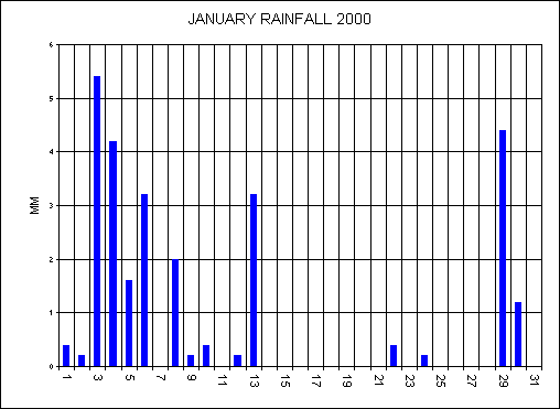
JANUARY
High pressure dominated most of the month. This January was the 2nd driest since my records began (1990) with only 27.2 millimetres. Temperatures turned out to be slightly lower than the average with an average mean of 5.4c (+.2C below average). The average maximum was 8.5c (+.3C above average) and the average minimum was 2.4c (-.6C). A low of -6.4C on the 27th was the lowest temperature since February 1991. The month had 15 days with rainfall, however rainfall on any given day was low with the wettest day of the month only having 5.4mm. For the 3rd year in a row now there has been no snow falling here at Bradninch.
OVERALL A SETTLED MONTH
FEBRUARY
February was a much milder month with a mild south westerly flow for most of the month. The average maximum temperature was 10.4C and this was 1.9C above the average. There was 26 days with rainfall, totalling 76.4mm for the whole month and this was 10.9mm above the average. With the mild weather all month there was only days with air frosts and only 1 day with snow falling on the 16th. Well levels fell due to the dry January.
OVERALL A VERY MILD, DAMP MONTH
WINTER SUMMARY (Dec 1999- Feb 2000)
Again, another winter with hardly any wintry weather here at Bradninch. It was another mild winter with an average maximum of 9.3C and this was 1C above average. The minimum was 0.1C below average, with 3C being the average for the winter. The mean was 6.1C and this was .5C above average. The mild winter has made many plants and shrubs flower all winter long. The last time we had a cold winter here was back in the winter of 1996-1997 with an average maximum of just 6.7C. This winter turned out to be the wettest since 1996 with a total of 280.6mm falling and was 36.6mm above the average. During the winter there was only 2 days with snow falling compared to 11 days during 1996.
OVERALL ANOTHER MILD, UNEVENTFUL WINTER
MARCH
High pressure brought a lot of dry, settled weather from the 4th. With a mild south westerly air stream established this resulted in some high temperatures. A glorious sunny day on the 13th resulted with a high of 17.4C here, with Torquay in Devon having 20C. From the 4th to the 22nd only 2mm of rainfall fell. A much colder end to the month as cold north easterlies set in. A high of only 6.9C under cloudy skies on the 29th and a biting cold wind to go with it. There was 13 days with rainfall totalling 40.6mm for the month and this was 12mm below the 10 year average. Temperatures were - 11.9C max (+.4C above average), 4.3 min (-.1C) and a mean of 8.1C (+.2C).
OVERALL DRY, MILD AND SETTLED UNTIL THE 22ND THEN MUCH COLDER
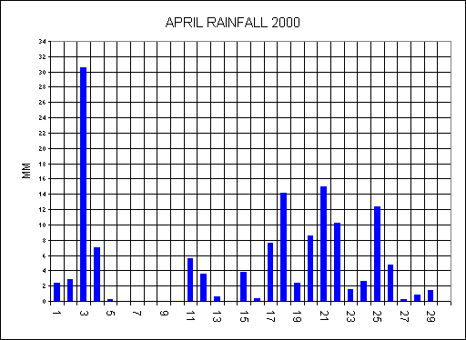
APRIL
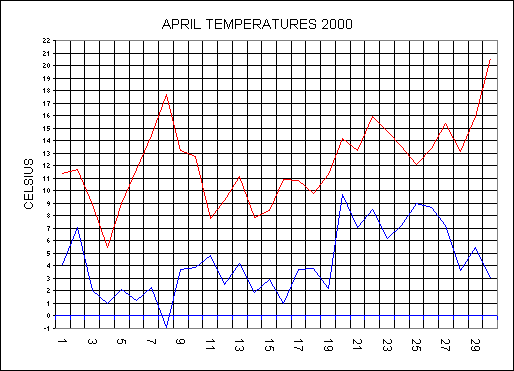
A bitterly cold start to the month with snow falling on the 3rd and 4th. Snow only settled on the highest hills in the mid-Devon area. This snow lingered on the hills until the 8th. The 3rd was also the wettest day of the year so far with 30.6mm falling during a 24 hour period. The 4th was a very cold day with a high of only 5.5C and a wind chill of -17C. With high pressure moved in from the 6th this brought higher temperatures and very dry air. The humidity was only 30% during the afternoon of the 7th. There was another cool spell around mid-month and this resulted in another snowfall to the highest parts of Dartmoor on the 15th. From the 17th to the 22nd more heavy rain fell with a total of 58mm falling during this period. Warmer air moved in from the Continent and this brought the highest April maximum temperature since 1997 with 20.6C on the 30th. There was only 7 dry days during the whole month. There was 1 air frost and 7 ground frosts during the month.
Rainfall for the month was 138.8mm (+64.4mm from 10yr average) and was the wettest April since my records began (1990). All this rain has caused the well levels to rise to their highest ever April level. This April turned out to be a very cool month with temperatures of :- 12.1C max (-1.3C from average), 4.3C min (-1.1C) and a mean of 8.2C (-1.3C). This April was the coolest since 1991 when we had the same 8.2C mean temperature.
OVERALL AN UNSETTLED, WET, COOL MONTH
MAY
The first week saw high pressure and resulted in a dry week. A thundery low moved out of France and this brought some humid air up across the country. The 7th was the warmest day of the month with 23.4C. With a flabby low pressure overhead and high temperatures this resulted in isolated thunderstorms to develop across the South West from the 6th to the 8th. The 7th was an interesting day as sea breezes set in on the south and north coasts of Devon and the caused a convergence zone across mid Devon. This is where 2 air masses collide and cloud is pushed upwards and usually results in thunderstorms especially under low pressure and high temperatures. Most of the afternoon storms on the 7th developed along this line of convergence. None of these storms produced any great lightning in the Bradninch area so I have not made any special reports. Low pressure remained near to the south of England up until the 11th with warm conditions and isolated storms. Here at Bradninch we escaped most of the showers and this resulted in only 7.8mm of rainfall up until the 16th. More mobile weather started to come in from the Atlantic from the 16th to the end of the month and this dropped the temperature back to normal. The 26th was a very cool, cloudy, day with a high of only 10.7C and this was also the wettest day of the month with 12.4mm. Well levels are still at their highest ever level.
Rainfall for the month was 60.8mm and was 10.8mm above the 10 year average. Temperatures where:- 16.9C max (-.8C from average), 8.3C min (+.2C) and a mean of 12.6C (-.3C). It turned out to be a coolest May since 1996 taking the mean into account.
THE FIRST HALF OF THE MONTH WAS WARM, DRY AND MOSTLY SETTLED AND THE 2ND HALF WAS COOL, AND VERY CHANGEABLE
SPRING SUMMARY (March-May)
It has just been the wettest Spring on record here at Bradninch with 240.2mm (9.45") beating the previous of 237.4mm set back in 1998. The 10 year average is 176.9mm (6.96"). Both April and May where cooler than average months and this has resulted in a cool Spring, the coolest since 1996. Spring temperatures were:- 13.6C (-.6C from average, 5.6C min (-.4C) and a mean of 9.6C (-.5C).
THE SPRING WAS COOL, OFTEN WET AND UNSETTLED
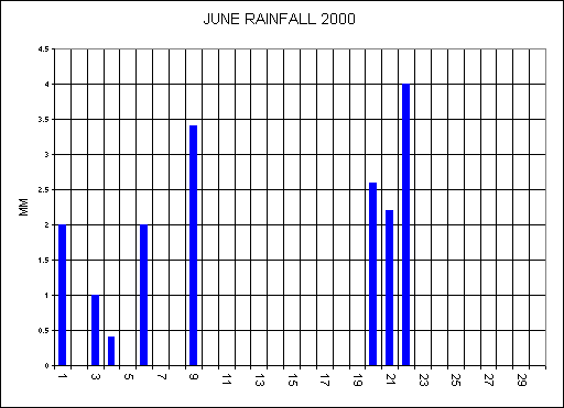
JUNE
This June has been a very quiet one with no severe weather around. Rainfall has been very low with no rainfall from the 10th - 19th and from 23rd to the 30th.. Warm southerly winds brought some very warm weather from the 17th with a high here of 26.8C on the 18th. Parts of Eastern England had 33C on the 18th and 19th. More mobile weather moved of the Atlantic from the 20th and this dropped the maximum to a high of only 16.8C by the 22nd. High pressure moved down from the NW from the 24th. This high was a cool one with a minimum temperature on the 25th of just 4.6C. Humidity was also low on the 26th with 34% as the minimum for that day. The last 3 days of the month had a maximum of over 23C.
The rainfall total for the month was 17.6mm and was the 3rd driest June since 1990. During June 1995 we only had 6mm. Temperatures were:- 20.2C (+.4 From average), Min 10.5C (-.2C) and a mean of 15.35C (0.0C).
JUNE WAS SETTLED, DRY AND WARM
JULY
The long dry spell of 20mm in 5 weeks came to an end on the 4th as 9.8mm fell. On the 7th there was a very heavy thundery downpour with 1mm falling in just 1minute. A total of 27.2mm fell during the first unsettled week of the month. From the 9th a low moved into the North Sea and this brought some cold winds from the North. The maximum on the 10th only reached 16.2C with a wind-chill of 3C. Pressure built from the West from the 14th and the temperature started to rise. The air in this high was very dry with only 29% humidity on the 18th, the 18th saw the coolest minimum of the month with 7.7C. From the 17th to the 21st the maximum temperature remained above 24C and the highest of the month was 26.9C on the 21st. The high gradually pulled away to Norway and this let flabby low pressure over France to move in on the 24th. With low pressure, warm temperatures and high humidity this was the ideal breeding grounds for thunderstorms to develop. On the 27th thunderstorms developed in the Taunton area and caused flash flooding also parts of Cornwall saw flash flooding too. The first rain for 2 week fell here at Bradninch on the 28th with 6.4mm falling during thundery showers. Exmouth had a deluge on the 28th with a staggering 43mm falling on the 28th. There was no thunderstorms over Bradninch this month, we seemed to have escaped.
Rainfall for the month was 43.8mm and this was only -2mm from the 10 year average. It has turned out to be a cool July with the lowest average minimum since records began. Temperatures were:- 21C (-.8 From average), Min 11.6C (-1.5C) and a mean of 16.3C (-1.1C).
HIGH PRESSURE DOMINATED A LARGE PART OF THE MONTH BRINGING SETTLED, DRY BUT SOMETIMES COOL WEATHER.
AUGUST
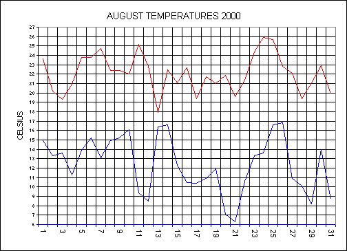
Pressure remained high here in the south at the start of the month with only weak fronts crossing the country. A warm front moved in from the west on the 5th this left us in a warm sector and the result was some very mild nights. From the 5th to the 10th the minimum didn't fall below 13C with the warmest night coming on the 10th with 16.1C. A cold front brought a 6.5C drop in the minimum on the 11th, but the daytime maximum on the 11th reached 25.2C with unbroken sunshine. With only 12mm of rainfall falling during the 30 days up to the 12th, this has resulted in a near drought condition. This drought ended on the 13th as a slow moving cold front brought thundery rain up from the south with 21mm falling during the dull, cloudy day. The 13th and 14th brought two very sticky, humid nights with a minimum on the 14th of 16.6C making this the warmest night of the year (see chart below). Low pressure moving down from the north west started to influence our weather from the 15th. This low brought thundery showers during the morning of the 18th with 6.2mm falling in 3 hours. During the night of the 18th a thunderstorm developed and this caused severe flooding to parts of Torquay and Exmouth. (Click here for LDS IMAGES) Here at Bradninch we missed the worst of the storm with only 6.2mm falling, but we did get some loud thunder and sheet lightning. There was a very chilly, early morning on the 21st, with a minimum of 6.3C at 6AM. This was the lowest August minimum since my records began beating the previous low of 6.4C during August 1991. More thunderstorms broke out across the country on the 20th and 21st bringing funnel clouds and some large hail falls. Hot humid air moved up from France from the 24th this brought the warmest day of the year on the 24th with 26.9C. More thunderstorms developed across the south but again we missed out here at Bradninch. Cooler air moved in at the end of the month.
August was a dry month with only 45.6mm and this was minus 31.5 mm from the 10 year average. It has turned out to be a fairly warm month but the minimum was lower than the average. Temperatures were:- 22C (+.7 From average), Min 12.4C (-.6C) and a mean of 17.2C (+.1C).
AUGUST WAS SETTLED, WARM BUT OFTEN CLOUDY
SUMMER SUMMARY
It has just been the 3rd driest Summer since records began back in 1990. Rainfall was only 107mm (4.21"). The 10 year average is 189.4mm (7.45"). Both July and August has had some very cool minimums and this has resulted in the lowest average Summer minimum since records began. Summer temperatures were:- 21C max (+.1C from average, 11.5C min (-.7C) and a mean of 16.2C (+.2C).
SUNSHINE THIS SUMMER HAS BEEN VERY LOW BUT IT HAS BEEN DRY LOCALLY AND WARM AT TIMES
SEPTEMBER
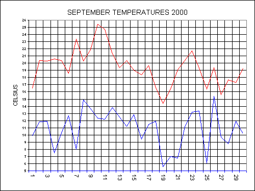
A very unsettled day greeted the month with low pressure sitting over the country, bringing some heavy showers with a rainfall total of 14.6mm for the 1st. A ridge of high pressure brought two fine days on the 2nd and 3rd with glorious Autumn sunshine. Westerly winds set in from the 4th with fronts quickly moving across the country but rainfall amounts here in the South were very low. A warm front moved up from the south on the 9th this brought some very high temperatures and very humid conditions. Unbroken sunshine on the 10th sent the maximum soaring to 25.4C and this was the warmest September day on record beating the 25.3C set in 1991. The hot weather continued on the 11th bringing another sunny day with a maximum temperature of 24.7C here with London having 29C. Most of the country seemed to be having a late taste of Summer, but this didn't last. A weak cold front moved down and became stationary over the south-west this brought a cloudy, very humid day on the 14th with humidity at 75% at midday. A new low moved along this front overnight on the 15th and this brought some thundery rain, with 45mm falling over west Cornwall, and 22mm falling here during an 8 hour period. As this low moved away it pulled in fresher air from the north west on the 16th. Low pressure established itself over the country from the 18th to the 22nd, with heavy downpours across the country. More mobile active lows moved across the country from the 24th until the end of the month. 46mm fell on west Dartmoor on the 27th but here to the east of the moors only had 6.6mm.
Rainfall for the month was 88.8mm and this was +5.4mm from the 10 year average. It has It has been the 4th wettest September since 1990. Temperatures were:- 19.4C Max (+1.5C From average), 10.9C Min (+.1) and a mean of 15.1C (+.8C).
This September saw the highest average maximum since records began.
THE MONTH AS A WHOLE WAS MILD BUT FAIRLY UNSETTLED
OCTOBER
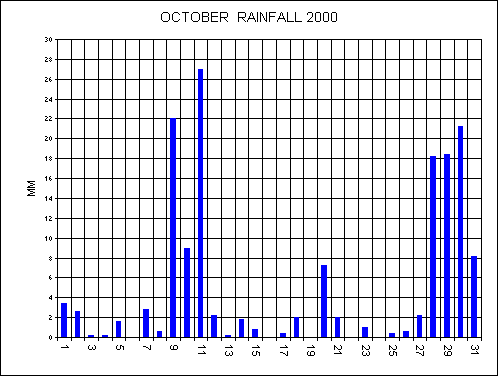
A deep low moved up the western side of the British Isles on the 3rd with gales in the west. This low moved away to the north and a weak cold front crossed the country with a ridge of high pressure following. The 5th and 6th were both fine, sunny Autumnal days. The first ground frost came on the morning of the 6th with an air temperature of 2.7C and a grass temperature of 0C. Low pressure came back on the 9th and this was the start of a very disturbed week across the country. An even deeper low moved around the southern flank of the existing low over the north to affect the south of England. If you looked at your barometer during the evening of the 10th you might have thought that it was giving the wrong reading but it wasn't. Pressure dropped like a stone as the low moved across our region. Pressure at 17:30 was 980mb and by 01:00 on the 11th it had dropped to 964.7mb making this the lowest pressure since my records began. As we were in the centre of the low the weather was quiet but over Northern France there was severe gales. This new low got combined with the existing low over northern England on the 11th and as a result the whole country experienced very wet conditions. Torrential showers moved down across the southwest during the afternoon of the 11th, with 16mm falling in just 4 hours and 27mm falling on the day itself. A total of 58mm fell in the 3 day period ending at midnight on the 11th. The 10th and 11th were both very cool days with a high on the 10th only reaching a poor 12.3C. East Sussex usually known for its dry weather experienced its worst flooding for 30 years on the 12th as 150mm (6 inches) fell during a 24 hour period. The low that caused all this weather filled and moved away on the 13th and pressure started to rise quickly. Low pressure dominated from the west from the 14th to the 27th.
The early hours of the 30th was very stormy as a deep low crossed the country bringing stormy winds and heavy rain. A total of 57.8mm fell in a 72 hour period. The River Culm at Hele was at its highest level for 20+ years. Many properties were flooded.
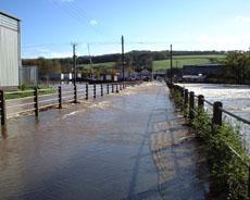 Click on photo for flooding photos.
Rainfall for the month was 156.2mm and this was +70.2mm from the 10 year average. It was the wettest October on record. Temperatures were:- 14.2C Max (+.3C From average), 7.1C Min (-.7) and a mean of 10.6C (-.3C).
OVERALL A VERY DISTURBED MONTH WITH SEVERE FLOODING ACROSS THE COUNTRY.
Did you notice that the House Martins were very late in migrating this year. I've even seen them still feeding their young on the 13th October- This could be a sign of a hard Winter to come.
NOVEMBER
The unsettled weather continued into November with low pressure over the whole of Northern Europe. Pressure fell on the 2nd as a showery low moved across the south of England. This low moved east with a small ridge of high pressure before another deepening low moved in on the 5th. Bonfire night was a washout for many, as 22.8mm fell on the day, accompanied by gales from the south east. Pressure on the 6th dropped to 973.6MB as a deep low moved across the Southwest. Sometimes when you are in the centre of a low the weather can be quiet and this was the case on the 6th. Here in Devon we escaped with no rain while most other parts of the country had a deluge. This low only slowly moved away over the next 4 days but then a new low took its place on the 11th bringing more rain with 10mm here. Pressure started to build from the 13th and this brought 3 cold nights. The first, white, air frost of the season with a low of minus 1.2C came on the 14th with a maximum for the day of only 7.1C. Forecasters didn't predict the heavy showers that moved down across our region on the afternoon of the 14th bringing a total of 4.4mm. Low pressure continued to move in from the Atlantic with a total of 34mm falling from the 16th to the 20th. There was a dry day on the 24th for a change but a new frontal system moved in of the Atlantic with more dull, gloomy weather. There was a change in the situation on the 27th as a warm front moved up from the south. This brought the mildest weather of the month with a high on the 28th of 14.9C and a low for the day of 11.7C.
It was another wet month but no records were broken. Rainfall for the month was 122.8mm and this was +23.4mm from the 10 year average. Temperatures were:- 10.6C Max (+.1C From average), 5.3C Min (-1.2) and a mean of 7.4C (-.5C).
OVERALL ANOTHER UNSETTLED MONTH WITH RAIN ON MOST DAYS
AUTUMN
As you expected it has been the wettest Autumn on record with a total of 367.8mm falling in the 3 month period ending on the 30th November. The 10 year average is 275.7mm, so this Autumn we have had 92.1mm above the average. Click here to Autumn rainfall charts. There was only 19 days with no rainfall during the 91 day period.
Temperatures were:- 14.7C (+.6 From average), Min 7.3C (-.6C) and a mean of 11C (0.0C)
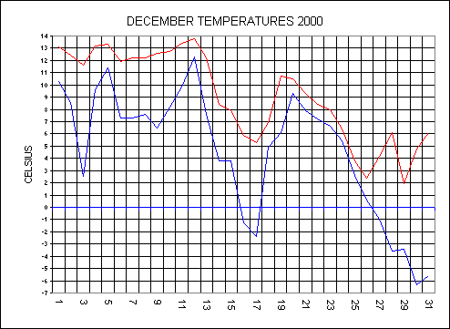
DECEMBER
Low pressure to the west of Ireland kept the British Isles in a run of southwester lies bringing more disturbed weather. 38.2mm fell from the 1st to the 6th and with another 31.4mm on the 7th this caused severe flooding in mid-Devon. The river Culm went to its highest ever level about 1ft higher than the end of October flood. Many properties were flooded for the 2nd time in a month. The river Clyst was also at a record level even coming over the B3181. The railway track at Cowley bridge in Exeter was washed away for the 2nd time in a month. Pressure on the 7th dropped to 976.7mb. Very mild air moved up from the south on the 12th behind a warm front with a high of 13.8C and a min for the day of 12.3C. Severe gales in the early hours of the 13th caused the roof of a new ward at the RD+E hospital blow off. There was gales on every day from the 3rd to the 13th. A ridge of high pressure moved in from the west on the 14th. Fronts started to come in from the Atlantic again from the 18th but they became stuck over the west due to high pressure over Norway. The fronts got pushed away to the northwest and a south-easterly breeze set in from the 21st. A cold front started to move down from the north on the 23rd bringing much colder air. Christmas day here at Bradninch was wet with cold rain and a raw wind. Dartmoor and N-Devon saw 6 hours of snow in the afternoon. The temperature started to drop with a high of only 2.4C on the 26th with a wind chill of -15C. Low pressure now in the north sea with a flow from the north over the country this brought very clear and sunny days from the 27th to the 30th. Troughs of low pressure brought snow bands down from the north with 2cm falling here at Bradninch in half an hour from 01:00 on the 28th and another 1cm at 23:30. The nights became bone chilling with a low of -6.4C on the 30th making this the coldest minimum of the year. After another very cold night the 31st saw a dramatic change in the weather as a deep low moved in from the Atlantic bringing milder wetter weather.
Rainfall for the month was 132.4mm and this was +30.8mm from the 10 year average. It has been a mild month mostly due to the mild first 2 weeks of the month. Temperatures were:- 9C Max (+1.1C From average), 4.6C Min (+1.7) and a mean of 6.8C (+1.4C). There was 13 days during the month with no sunshine and only 1 day with unbroken sunshine.
It has been another wet year with a total of 951mm(37.44") and this was +68.5mm from the 10 year average. Temperatures were .5C lower than last year with:- 14.6C Max (+.3C From average), 7C Min (-.2) and a mean of 10.8C (-.1C).