![]()
MONTHLY AND SEASONAL REPORTS ON THE WEATHER DURING 2001 FROM BRADNINCH (Weather records started in 1990)
( See also charts by month from statistics main page)
Occasionally there might be links from this page to other pages especially if there is any severe or unusual weather like thunderstorms or any charts of interest, ect. All links will be in blue and don't forget to use the back button on your browser to return to this page.
REPORTS BY MONTH= Jan, Feb, Mar, Apr, May, Jun, Jul, Aug, Sep, Oct, Nov, Dec.
REPORTS BY SEASON= Winter, Spring, Summer, Autumn.
JANUARY
Low pressure greeted the year with the wettest day of the month on the 1st with 15.8mm. Low pressure continued to move in from the Atlantic and this meant the temperatures stayed on the mild side. High pressure built from the east from the 7th with cooler conditions while a low affected us here in the south. A bitterly cold north easterly breeze picked up with wind-chill down to -12C on the 11th. The cloud over the south moved away to leave the 13th and 14th with unbroken sunshine but it was still on the cool side. A small trough moved out of France on the 16th and this brought a cloudy bitterly cold day with a high of only 1.7C. A weak low moved up from the SW from the 18th. The coldest min of the month came on the 20th with -2.4C. A big change from the 21st as Atlantic fronts started to move from west to east and this situation remained for the rest of the month. 38mm fell during a 3 day period from the 21st. A very active cold front crossed the SW on the 23rd and this brought thunderstorms on the back edge. Thunder was also heard here on the 24th. Westerly brought showers across the country from the 25th with snow falling on hills on the 26th. A ridge of high pressure on the 29th brought another air frost. A weak front erratically crossed the country on the 30th and 31st.
Rainfall for the month was 106.6mm and this was only +22.5mm from the 10 year average. It has turned out to be a cool January. Temperatures were:- 7.6C (-.9 From average), Min 2C (-.7C) and a mean of 4.8C (-.5C).
This January saw the highest number of ground frosts since records began(1990).
FEBRUARY
The first week of the month saw a north south split in the weather. High pressure stretching from Greenland to Sweden kept Scotland and northern England under a bitterly cold air stream. Blizzards affected these parts with daytime temperatures only reaching minus 1C. From the Midlands southwards there was very mild weather due to fronts coming of the mild Atlantic. The maximum temperature here at Bradninch on the 5th was 13.2C and was some 15C higher than it was in the North. A deepening low brought milder air to the north on the 6th and the deep snow melted quickly. The first thunderstorm to occur in February since my records began came on the 6th. There was Fork lightning with hail and torrential rain over many parts of the South west during the 6th. Thunderstorms in the late winter over land are fairly rare as they need heat to regenerate. Thunderstorms are more common in Winter over the milder sea's around the British Isles. A ridge of high pressure moved across the country on the 8th and this temporarily cut off the Atlantic feed of mild weather. Mild air once again moved in as a warm front pushed Northwards from the 10th. There was only a 1.7C temperature difference from the maximum and minimum on the 11th with a Max of 13.1C and a Min of 11.4C (see chart below left). This 11.4C was the highest February minimum since my records began beating the previous record of 10C during 1997. After 3 months with no long lasting settled weather the whole country was in for a real treat from the 12th. High pressure moved in and stayed around for the next 9 days bringing lots of dry, sunny weather. It was mild by day but cold at night with minimums below freezing with a low on the 19th of minus 3.3C. Much colder air moved Southwards from the 24th bringing snow to parts of the country. A band of snow moved down across the country and gave 1cm of lying snow here on the 25th. Severe blizzards affected Scotland and northern England from the 25th to 28th. We here at Bradninch only had a few light snow showers on the 28th.�
Rainfall for the month was lower than the average with 49.8 mm and this -15.7mm from the 10 year average. Rain fell on 17 days with a highest daily total of 9mm on the 6th. There was a lot of high maximums during the month and also a lot of sub zero temps. Air frosts totalled 12 and ground frosts for the month was only 3. Temperatures were:-� 9.7C (+1 From average), Min 2.3C (-.5C) and a mean of 6C (+.3C).
WINTER SUMMARY (Dec 2000- Feb 2001)
Again another wet season with 288.8mm (11.37") and this was +44.5mm above the 10 year average.�It has been the
wettest Winter since 1995. This Winter was the coolest since 1997. The bulk of the movement of the weather systems came across from the west bringing mild air.�There was only one dry spell with high pressure and this was in the middle of February. Temperatures were:- Max 8.7C (+.4), Min 2.9C (-.2) and a mean of 5.8C (+.1). �
AN UNSETTLED WINTER WITH AN ATLANTIC INFLUENCE�
MARCH
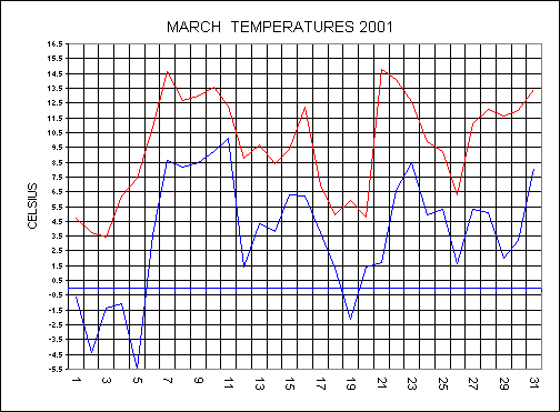
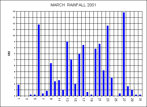
March started as February left off with a cold blast from the north-east. The maximum temperature on the 3rd only managed to reach 3.4C making this the coldest march day since records began (1990). With a raw easterly wind and cloudy skies this 3.4C felt more like minus 14C during the afternoon. Another record got broken on the 5th with a minimum of minus 5.5C beating the previous low of minus 2.1C set in 1993. The first 5 days of the month all had minimum temperatures below freezing and some damage to spring blossom occurred. A dramatic change in the weather from the 6th as a warm front moved up from the south giving 11.8MM of heavy rain. The warm front also brought a rapid rise in temperatures across the country. The maximum on the 7th climbed to 14.6C and this was 11.2C higher than it was just 4 days before. Fronts started to move from west to east off the Atlantic and it remained mild and damp to the 11th. A low moved across the region overnight on the 11th and gave 9MM of rainfall. Colder air moved down from the north from the 13th and a battle ground between the cold air to the north and the mild air to the south started. A warm front moved up from the south and this became stationary over the midlands on the 17th. Colder air from the north started to under-cut this front and the rain turned to snow in parts. The 17th was wet and cloudy here with an afternoon temperature of only 3.8C. The colder air from the north won and the front moved back southwards. Temperatures dropped again as we slipped into the 2nd wintry spell of the month. An occluded front moved up from the south on the 20th and as this met the cold air the rain turned quickly to snow. Blizzard conditions affected parts of Devon and there was a biting north-easterly wind making it feel like minus 14C. The 21st was a totally different day with warm sunshine and a high of 14.8C. An active frontal system moved up from the southwest on the 27th and this brought the wettest day of the month with 13.8MM.
It has been the wettest March since 1963 with 112.2MM falling, this was + 59.6MM above the average. Rain fell on 28 days during the month. Click here to see how this March's rainfall fits into the chart for 1905-2001. It has been a cool month with temperatures of: Max � 9.7C (-1.5 From average), Min 3.6C (-.8C) and a mean of 6.6C (-1.2C).
The temperature chart below shows the two cold spells and the mild spell during the month. Never before can I remember such an interesting temperature pattern for March. The rainfall chart below is interesting as we only had 3 dry days during the month.
APRIL
The unsettled theme continued into the start of April with a south westerly flow. A low moved across the south bringing 12.4MM during the evening of the 3rd. Gales affected the south on the 5th and 6th as a frontal system moved in bringing mostly light rain and mild conditions. An evening shower on the 6th brought a spectacular full twin rainbow across the whole sky. As these fronts moved across the country the wind turned northerly and as a result we had a ground frost on the 7th. A low moved down from Iceland on the 9th and 10th bringing 6.6MM on the 9th. Pressure at last started to build from the west on the 12th bringing that much welcomed dry spell. There was a little hiccup as a weakening frontal system moved into this high with some drizzle on the 12th and 13th. This front became stubborn to move away and as a result we had 3 days with no sunshine to the 14th and it was also chilly with a high of only 8.9C on the 13th. The front finally moved southwards overnight on the 14th and the high re-established itself. Due to the position of the high to the west of the UK this resulted in a northerly again. Easter Sunday the 15th was a much brighter day with excellent visibility and lots of sunshine with a maximum of 14C. The high remained to the west of the UK to the 20th, with a cool flow from the north and some ground frosts occurred in places. A cloudy wet day on the 22nd with a front over the south this brought a total of 15.8MM making this the wettest day of the month. The 22nd was also the coldest day with a maximum of 8.9C. It remained unsettled with bands of rain moving up from the SW. Visibility from the 27th to the end of the month was excellent due to cold upper air coming from west. The air was also very dry with a low humidity of 35% on the 30th. There was an air frost on the 30th with a low of -.7C making this the latest air frost since records began.
It has been a yet another cool month with below average temperatures. Temperatures were: Max �12.5C (-.8 From average), Min 4.5C (-.8C) and a mean of 8.5C (-.8C). Rainfall was 82.8MM and this was +8.4mm above the average.
MAY
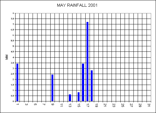
High pressure stayed to the west of the British Isles until the 7th this brought a lot of dry settled weather under a northerly flow. The air was very clear and dry with a low humidity of 37% on the 4th and 8th. The high started to move northwards from the 9th and this resulted in a Continental flow across the country. Sporadic thunderstorms affected the south with one over the Wellington area on the evening of the 10th. The temperature started to climb day by day to reach a maximum of 26.1C on the 12th and this was hotter than most of Continent. It was the warmest may day here for 3 years but this hot spell didn�t last. Sunday the 13th was an interesting day and can be split into two halves. The morning was warm and humid with very poor visibility under cloudy skies. A cold front moved across Devon during the afternoon, and as this cleared the air turned noticeably fresher and clearer. Within half an hour there was a total transformation in the weather all thanks to the cold front. Low pressure over Biscay brought showery rain up from the south but here at Bradninch we missed all the heavy downpours. Another low from the north joined hands with the one to the south from the 16th. A very cold feel to the day on the 17th as we had gales from the west under cloudy skies with a maximum of only 11.8C. Pressure started to rise from the south from the 18th to bring another fine, warm and settled spell up until the 25th with rising temperatures again. A warm front moved up from the south on the 27th this brought warm, muggy conditions with a high of 24.6C on the 28th. A cold front cleared the air to much fresher conditions from the 29th and there was a cool end to the month.
It has been the driest May since 1991 with only 20.6MM and this was -31.5MM below the average (see chart below). The maximum was 18.6C (+1C from average), Min was 7.8C (-.3C) and the mean was 13.2C (+.3C).
OVERALL A VERY SETTLED, DRY, WARM AND SUNNY MONTH
SPRING SUMMARY (March-May)
Both March and April were very unsettled with lots of rain and quiet cool with it. May was the opposite with dry, settled and warm conditions.
Rainfall was 215.6MM and this was +38.7MM from the average. Temperatures were: Max 13.6C (-.4C from Ave), Min 5.3C (-.7) and the mean was 9.4C (-.6C).
JUNE
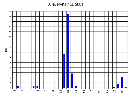
Pressure remained to the west of the British Isles to the 3rd> with very weak fronts moving down from the north. A cold front brought only 0.4MM on the 2nd and this was the first rainfall for 2 weeks. The high to the west extended across the country and into Europe on the 4th bringing a day of glorious sunshine and a high of 21.9C here. Pressure slackened on the 5th and sporadic showers developed across the south of England. St. Mawgan in Cornwall had a staggering 51.4MM (2.02 inches) during a thunderstorm in a 4 hour period while we here at Bradninch remained dry all day. A cool pool of air moved down from the north behind a cold front on the 6th and we remained in this northerly air stream to the 11th. With the flow from the north this resulted in low humidity and cold nights. The minimum on the 9th dropped to 2.6C at 05:46 and this resulted in a frost on the grass. This was the coldest June night on record and also the latest ground frost to occur since 1991. Pressure started to rise from the south on the 11th but weak fronts again moved into this high bringing a lot of cloud from the north. Since the 19th may to the 13th June it has remained remarkably dry here at Bradninch with only 1.2MM falling during this 24 day period. A dramatic change in the weather as a vigorous low moved across the south of England from the 14th and the drought ended as 6.6MM fell on this day. The 14th was an interesting day as there was high humidity, high dewpoint and warmth all the ideal breeding grounds for thundery activity. Two thunderstorms developed just to the north of Bradninch around midday and these merged with others to bring flash flooding to the west Midlands during the afternoon. More thundery rain from the south during the evening of the 15th gave a total of 14.4MM for the day. Pressure started to build from the south from the 17th to bring a fine, warm and sunny spell. Humid air moved up from the south bringing a high of 28.8C on the 25th making this the warmest day since July 1999. Fronts moved in from the west from the 27th with an active cold front bringing 2.2mm in an evening shower on the 29th.
Another dry month with only 28.8MM and this was -33.3MM below the average (see chart below). The maximum was 20.6C (+.7C from average), Min was 9.2C, (-1.5C the lowest average min since records began) and the mean was 14.9C (-.4C).
OVERALL A DRY MOSTLY SETTLED MONTH AGAIN AND VERY WARM AT TIMES
JULY
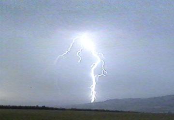
4TH JULY THUNDERSTORMS
A cold front started to move erratically across our region during the evening of the 3rd. Thunderstorms over Cornwall moved into Devon at 23:30 first moving along the coast then coming inland. Over the next 6 hours there was continuous lightning over Devon mainly CC (Cloud to Cloud or sheet) at first and then CG (Cloud to Ground or fork) from 02:00 on the 4th. From day break at 04:00 there was new storms developing on the back edge of the main storm. Within 20 minutes these new storms grew and all produced CG lightning. I observed 2 CG strikes within 2 miles with the first one hitting a tree at Killerton and this one below that hit silo�s on the Clyst hydon road. During the 24 hours to 17:00 on the 4th my Lightning Detection System recorded 55,000 strikes in a 300 mile radius of Bradninch. This was the most strikes in a 24 hour period since I had the LDS installed back in 1997. Check out lightning photos, LDS images and animations of lightning strikes. There was also dramatic cloud formations around 05:00 and these are included on the photos page. Never before can I remember a continuous series of storms lasting 6 hours, do you?. Rainfall during these storms only amounted to 14.4MM. However, this ended the drought conditions that we have had for weeks.
FROM THE 5TH
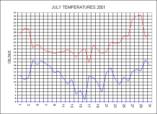
The thundery conditions moved across the country and this left us here with mostly cloudy skies on the 5th and 6th. The low over the south slowly pulled away to the east on the 7th and this allowed the much awaited fresher air to move in from the west. The nights from the 4th to the 8th were very warm due to cloud cover with the minimum not falling below 15C (see chart below). A situation more associated with the Autumn as a deep low brought gales on the 11th. As this low moved east the wind turned northerly and it got fairly chilly especially at night. The minimum on the 16th dropped to 4.6C and this was the lowest July minimum since records began (1990). The unsettled theme continued with Atlantic lows moving across the country. Pressure started to rise from the 24th to bring a heat wave with a maximum on the 29th reaching 30.2C making this the hottest day since Aug 1995. 10 dry days ended the month.
Rainfall for the month was 64.8MM and this was +18.9MM above the average. The average maximum was 21.7C (0.0C from average), Min was 11.9C, (-1C) and the mean was 16.8C (-.5C).
THIS JULY WAS A MONTH OF EXTREMES
AUGUST
Fronts moved down from the North-West from the 1st this brought showery rain across the country. This showery air-stream continued until the 6th when a more active frontal system moved in from the West. Low pressure over the whole country on the 7th bringing gales but rainfall amounts at Bradninch were low. The low moved away to allow a ridge of high pressure to move in from the west. The minimum on the 10th dropped to 6.6C with a maximum for the day of 20.9C. Another frontal system moved across the north with us here in the south remaining under higher pressure. Very warm and humid air moved up from the south on the 15th with a high of 28.2C but a cold front was moving erratically in from the west. The 16th saw much fresher westerly air but in this fresher air showers still developed with a thunderstorm that developed over Bradninch with hail and 11.2 mm in just 20 minutes. A low moved into Biscay on the 17th with its fronts then moving north to affect us in the south. Outbreaks of rain all day on the 18th gave 10.4 mm for the day. After a quiet spell a weak cold front moved in from the west this became trapped in a high over the country with little ripples running along it. In the south there was a feed of the Continent again so the temperature climbed again. 24.4C on the 23rd and 24.2C on the 24th with the 2nd highest of the month coming on the 25th with 28.1C. The cold front finally cleared the south coast bringing again much fresher air. High pressure moved in behind this front with glorious sunshine and excellent visibility. Bank holiday Monday the 27th had unbroken sunshine with a high of 21.4C. Another weak cold front moved down from the west on the 30th.
Rainfall for the month was again very variable with a total of 45.8 MM and this was -32.6 MM below the average. The average maximum was 21.8C (+.5C from average), Min was 12.8C, (-.2C) and the mean was 17.3C (-.2C).
OVERALL A MIXED MONTH WITH LOTS OF WARM SUNSHINE INTERSPERSED WITH SHOWERS AT TIMES
SUMMER SUMMARY
The Summer has been fairly average with lots of dry spells giving way to the ground becoming very dry. There was no prolonged drought as rain came just in time to recover the grass. The Summer was mostly dominated by a SW to NW air stream with the occasional southerly flow bringing hot air from the south. There was some very chilly nights with a record breaking 4.6C on the 16th July. The most dramatic weather event for Bradninch was the thunderstorms of the 4th July as detailed above.
AN AVERAGE SUMMER
Rainfall was 139.4MM and this was -50MM from the average. Temperatures were: Max 21.3C (+.4C from Ave), Min 11.3C (-.9) and the mean was 16.3C (-.1C).
SEPTEMBER
There was a blocking situation from the 1st to the 19th with high pressure situated in the north Atlantic and this kept the British Isles under a north to north-westerly flow. We here in the south-west had the best of the weather as any fronts that did move down were very weak bringing only light rain. With a flow from the north the air was dry, clear and clean with no pollution. Up to the 19th rainfall for the month was only 11.4MM. From the 20th August to the 24th September rainfall only totalled 13.8mm. Grass was all brown and many shrubs were suffering in the near drought conditions. A dramatic change from the 26th as Atlantic fronts moved in from the SW bringing rain and wind. During the evening of the 26th there was a one strike CG flash near to Bradninch at 10:20 pm, this gave a loud rumble of thunder.
Rainfall for the month was 27.6MM and this was minus 61.2MM below the average of 88.8MM. If it was not for the rain at the end of the month it would have been the driest September for 30 years.
Temperatures were - Max 18.5C (+.5C), Min 10C (-.8C) and the mean was 14.3C (-.1C).
OCTOBER
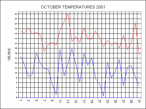
Low pressure in control bringing lots of frontal systems across the country during the first week. A very deep low with pressure down to 983.3MB moved across the south of England on the 7th with severe gales and heavy rain, totalling 18.6MM. During this first unsettled week of the month we had a total of 48MM. The ground was from being very dry to now very wet and the grass has recovered well back to its green state. There was a very heavy dew on the 10th with a low of 5.6C under clear skies. Pressure started to build from the Continent and a mini Indian Summer moved in. The 11th - 13th all started dull and gloomy but the sun came through and gave very warm, sunny afternoons. The maximum on the 13th reached 22C making it the warmest October day here for 4 years. London had a high of 25C on the 13th. The 13th was also unusually very humid with 97% (Max) and 76% (Min) and under calm conditions it felt oppressive as there was no cooling effect. Cooler air swept in from the west on the 15th and it remained unsettled to the 20th. Another cold front brought some very interesting cast cumulus cloud formations at 7 am. There was thunder in the distance towards Dartmoor. NORTHERN LIGHTS were visible during the evening of the 21st with a red glow right across the sky. More lows moved of the Atlantic to the 26th. Thundery downpours developed along a waving cold front over the south this gave a total of 23.8MM on the 26th. 20.2C in a warm sector on the 30th was a very unusually warm late October day. A cold front brought a return to normal temperatures to end the month on the 31st. Well level at Crofthayes was still at a record low level at the end of the month.
IT HAS BEEN THE WARMEST OCTOBER SINCE RECORDS BEGAN SOME 342 YEARS AGO. This was mostly due to the continuous south to south westerly flow due to a blocking situation with high to the east and lows over the northern Atlantic.
Temperatures were - Max 17.1C (+3.2C), Min 10.5C (+2.8C) and the mean was 13.8C (+3C).
Rainfall was 129.8MM and this was +36.8mm above the average.
NOVEMBER
High pressure with a central pressure of 1040.7MB over the south west greeted the month bringing dry, settled weather. This high gradually pulled away back into the Atlantic to allow fronts to move down from the north west from the 6th. A cold front moved down from the north on the 8th to bring an Arctic blast to the country. Snow showers fell to many parts of the country on the 8th including here at Bradninch. The maximum temperature on the 9th only reached 7.3C with a bitingly cold northerly breeze and it felt more like minus 9C with the wind chill factor. The first air frost came on the 10th with a low of minus 2.1C. The high moved back across the country from the 13th and this dominated the weather to the 21st. It started of as a sunny high but cloud filled in to bring dull, chilly days. More active fronts moved in from the Atlantic to bring a more changeable end to the month. 9.8MM fell on the 29th making this the wettest day of the month.
Trees have kept their leaves on to very late this year this is due to the mild October and the lack of wind during November to blow them off. The colours have also been spectacular thus year. There was 8 calm days during the month and no days with gales.
Rainfall for the month was only 42.2MM and this was minus 60.8MM below the average of 103MM. It has been the driest November since my records began. Well level at Crofthayes has also seen the lowest November level since I've been recording the well.
Temperatures were - Max 12C (+1.5C), Min 4.4C (-.8C) and the mean was 8.2C (+.4C).
A VERY SETTLED, MILD, CALM AND DRY MONTH
AUTUMN
A very quiet Autumn with September and November having below average rainfall. October was wet but incredibly mild with record breaking temps. There has been no stormy weather during the autumn period.
Rainfall was only 199.6MM and this was -78.1MM from the average.
Temperatures were: Max 15.8C (+1.7C from Ave), Min 8.3C (+-4) and the mean was 8.3C (+.4C). The max and mean has been the mildest since records began.
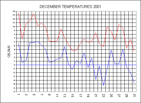
DECEMBER
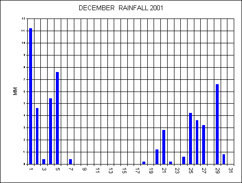
The first week saw Atlantic weak fronts move across the country from the west. Pressure built from the south from the 7th and remained for the rest of the month with a few exceptions. There was glorious winter sunshine with 6 unbroken sunshine days from the 7th to the 15th. No rain fell during this period as you can see in the chart below. The high gradually moved northwards to allow a cold feed off the Continent bringing lower temps. From the 19th the high moved back westwards to allow a cold front to move down bringing an Artic blast. The 21st saw freezing rain and 50+ vehicle accidents in the mid-Devon area during daybreak. The minimum on the 23rd dropped to -5.4C but the day saw glorious sunshine again. Xmas day saw a SNOW shower during the evening here with many places over the country having snow on Xmas day. A cold front moved down from the north on the 28th and this lingered in the English channel before moving back to affect the south of the UK during the early hours of the 29th. This milder air from the south came up across cold air from the north and as a result we had snow. A total of 1.5cm fell from 2:30 - 8am giving a covering in the Bradninch area. High pressure took over again at the end of the month bringing the last day of 2001 with unbroken sunshine with a minimum of -4.7C.
Temperatures were: Max 7.6C (-.4C from Ave), Min 1.2C (-1-9) and the mean was 4.4C (1.2C). This December saw the lowest average minimum since records began.
Rainfall was also very low with only 53MM and this was -53.3MM below the average.
OVERALL A VERY SETTLED, SUNNY BUT COLD MONTH
It has been the driest year since 1996 with only 764MM falling and this was - 148.1MM below the average of 912.1MM (my 10 yr ave 91-00). The end of the year was particularly dry with both Nov and Dec having well below average rainfall. This might have a dramatic impact on the reservoir levels next summer with a drought possible. Well level at Crofthayes was a record low level from Aug - Dec. Taking each day of the week into account the wettest day of the week during the whole year was Thursdays with 35 and the driest day was Mondays with 23 days.
Temperatures were: Max 14.7C (+.4C from Ave), Min 6.6C (-.6) and the mean was 10.7C (-.1C). So temperatures have been around average. The min would have been a lot higher if it was not for the low minimums during December.
The Autumn was remarkable this year with low rainfall and not much wind this resulted in spectacular Autumn colour on the trees. The only dramatic weather during the whole year was the July the 4th Thunderstorms that gave 6 hours of lightning in our area.
A QUIET MOSTLY SETTLED YEAR