![]()
MONTHLY AND SEASONAL REPORTS ON THE WEATHER DURING 2002 FROM BRADNINCH (Weather records started in 1990)
( See also charts by month from statistics main page)
Occasionally there might be links from this page to other pages especially if there is any severe or unusual weather like thunderstorms or any charts of interest, ect. All links will be in blue and don't forget to use the back button on your browser to return to this page.
REPORTS BY MONTH= Jan, Feb, Mar, Apr, May, Jun, Jul, Aug, Sep, Oct, Nov, Dec.
REPORTS BY SEASON= Winter, Spring, Summer, Autumn.
JANUARY
The month started cold with a low of - 4.7C on the 1st with chilly south easterly winds. This cold spell continued until the 9th then we had a feed off the Atlantic. This brought some long awaited heavy rainfall and much higher temps. From the 12th the Maximum stayed above 10C with the exception of a few days. Front after front crossed the country with mostly light rain to the south at first then more active fronts moved in with some stormy weather especially over Scotland with gust to 90 - 100 mph on the 28th and this brought down trees and damaged buildings. The 29th was very mild with a high of 14.2C and this was reflected in the average for the month as it has been the mildest January on record for the average maximum. Well level at Crofthayes is still at a 6 month low with only 3.6 ft at the end of Jan.
Rainfall for the month was 103.8mm and this was only +19.7mm from the 10 year average. It has turned out to be a very mild January. Temperatures were:- 9.8C (+1.9 From average), Min 4.4C (+1.7C) and a mean of 7.1C (+1.8C).
FEBRUARY
A very disturbed start to the month with severe gales from the south west on the 1st. This brought down a large tree on the B3191 near Broadclyst and many others got brought down in the mid Devon area. I recorded gales on every day to the 5th as many active fronts crossed the country from the Atlantic, but it remained very mild. The 8th saw us in a warm sector and this brought a maximum of 13.8C under cloudy skies. The first 12 days of the month have been exceptionally mild all brought about by a Maritime Tropical Air Mass (Azores high) which kept all the weather coming up from the south west. The average maximum for the first twelve days of the month was a staggering 12.2C and that’s 3.5C above the 10 year average of 8.7C. So again we are experiencing a very early start to Spring with trees and shrubs budding out very early. However, we may not be clear of Winter yet, as we can still get some severe frosts like we did on the 5th of March last year with a low of minus 5.5C. Also do you remember the heavy snowfall of the 15th April 1999? High pressure built across the country from the 13th and this brought a settled often sunny spell to the 17th. Active fronts again moved in from the west on the 19th to bring more wind and rain, and it remained unsettled to the the end of the month. There was a few sleet showers on the 26th and 27th.
Rainfall for the month was 112.6mm and this was only +53.6mm from the 10 year average. There was only 3 dry days during the whole month. It has turned out to be another very mild month. Temperatures were:- 10.8C (+2 From average), Min 4.7C (+1.9C) and a mean of 7.7C (+2C).
WINTER SUMMARY (Dec 2001- Feb 2002)
Most of the rain fell during January and February with a total for the Winter of 269.4 and this was +19.9mm above the 10 year average. Well levels rose rapidly at the end of February. Despite the cold December the season has turned out to be mild with above average temperatures. Temperatures were:- Max 9.4C (+1.1), Min 3.4C (+.3) and a mean of 6.4C (+.7).
A MOSTLY UNSETTLED WINTER WITH RAIN AT FREQUENT INTERVALS
MARCH
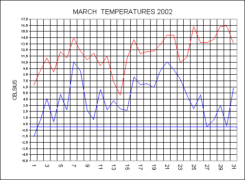
From the 1st to the 8th there was a split in the weather with the north having rain and the south having a dry spell under high pressure. The high moved back into the Atlantic to allow active fronts to move right down across the country from the 9th. A low tracked into Biscay on Monday 11th and this dominated our weather here in the south for the rest of the week. Pressure built to the north and with low pressure over France it meant that there was a squeeze of winds over the south of England. As you can see by the temperature chart below, on the 14th the maximum only reached 5.2C but it felt more like minus twelve (wind chill) with the gale force easterly wind. Snow fell on Dartmoor and Exmoor on the 14th. The high to the north moved into Scandinavia and this allowed fronts to move up from the south and therefore cut off the cold easterly flow. It remained unsettled in the south with fronts moving of the Atlantic until the 20th. High pressure built across the whole country on the 22nd to bring a lot of fine, sunny, and settled conditions to the 30th. From the 28th to the 30th there was unbroken sunshine and the temperature climbed to 16.4C on the 30th. A breakdown in the settled spell started on the 31st.
Most of the rainfall for the month came in the middle of the month with 57mm falling in total and this was only - 1.8 mm from the 10 year average. Temperatures were near to the long term average:- Max 12C (+.8 From average), Min 4.6C (+.2C) and a mean of 8.3C (+.5C).
APRIL
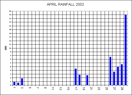
High pressure over all of mainland Europe and a low to the west of Ireland kept us here in the southwest under a southerly flow. A warm front moved up from France during the evening of the 2nd and this brought the first thunderstorms of the season that moved across Dorset and Somerset. Another low moved into Biscay on the 5th taking all the unsettled weather into France, Spain and Portugal. High pressure built across the British Isles from the north and it was this high that dominated our weather over the next week. The 6th saw much drier and clearer air move in from the northeast bringing lots of sunshine. There was unbroken sunshine on the 6th and 7th, but there was also gales from the northeast and it made feel more like minus 11C early on the 7th. The high by the 8th stretched from the Azores across the British Isles and into Russia, a span of some 4.500 miles (7.240KM). While we enjoyed fine, settled conditions from the 6th to the 13th most of central Europe had very unsettled weather during the same period. The chilly winds prevailed here to the 13th and it remained dry and mostly sunny to the 16th. Only 3.2MM of rain fell up to the 16th of the month and only 5.8MM had fallen since the 22nd of March (25 days). The ground had become unusually dry so early in the season with the grass even stopped growing. A breakdown in the weather started on the 17th as an active cold front moved across the country and this brought 4.4MM of much needed rainfall Pressure built again from the south from the 19th but weak fronts turned it cloudy as they went through the high. A warm sector across the country on the 23rd and 24th with high pressure and sunny conditions. A deepening low moved down from Iceland on the 26th to bring an unsettled end to the month with much needed rainfall. A very wet day ended the month with 19 mm falling.
Rainfall for the month was 53.8 mm and this was minus 30.8 mm from the 10 year average. Temperatures were near to the long term average:- Max 14C (+.7C From average), Min5.2C (-.1C) and a mean of 9.6C (+.3C).
MAY
The 1st saw a low move away to the northeast and pressure started to build from the west. There was a chilly northerly flow with a ground frost on the 2nd and 3rd. The ground frost on the 3rd will most probably be the last of the season, hopefully. The earliest date for the last ground frost since my records began was on the 27th April 1991, and the latest ground frost was last year on the 9th June. A messy scene on the bank holiday Monday with high pressure and several weak fronts over the country, bringing a lot of cloud. This high to the west of the UK brought a chilly northerly flow to the 11th. A vigorous low moved in from the west and this brought a breakdown in the settled spell from the 13th. A cold front moved east on the 13th with gales from the southwest, and a total of 16.2MM falling on the day. The 15th saw a warm front move northwards up across the country and pressure built from the south. The low that brought the warm front became stuck in the Atlantic, as it could not move anywhere as it became surrounded by high pressure, which would not give way. With a southerly flow all the way from Africa on the 16th, the whole country had a mini heatwave. The temperature climbed to 22.5C here, and highs of 27 to 29C over the eastern England. The English saying; ‘two fine days and a thunderstorm’ became true this time as the 17th saw a breakdown. The cold front from the low moved erratically eastwards on the 17th. Thunderstorms broke out ahead of the cold front from 03:30 and these moved into Devon from the south. My vantage point was Caseberry hill, were I had good views of the Exeter area. I managed to photograph some spectacular strikes near to Exeter before taking shelter as the rain arrived.
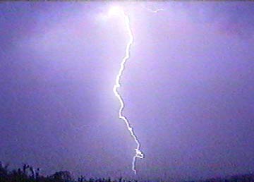 Click here or on
photo to take you to see all the photos from this storm
Click here or on
photo to take you to see all the photos from this storm
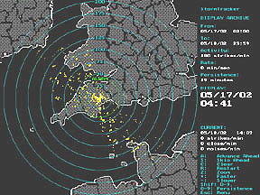 Click here or on image
(left) to take you to see the lightning detection images.
Click here or on image
(left) to take you to see the lightning detection images.
This storm moved away but more followed at 11 am to bring more torrential rain to our area. The cold front cleared all the thundery weather away by the 18th, but it remained very unsettled with rain and GALES at times to the end of the month. A mobile west to south westerly flow from the 19th to the 30th. The last day of the month was dry.
RECORD breaking rainfall for the month with 99.6 mm and this was 44.5 mm above the 10 year average of 55.1mm. It has been a very chilly month with the average maximum of 16.1C, this being some 1.5C below the average of 17.6C. Min 7.4C (-.7C) and a mean of 11.7C (-1.2C).
IT WAS THE COOLEST MAY SINCE 1996, WETTEST ON RECORD, RECORD NUMBER OF WET DAYS IN THE MONTH (20) AND WELL LEVELS AT CROFTHAYES AT A RECORD HIGH LEVEL FOR MAY
SPRING SUMMARY (March-May)
Most of the rain fell during May as both March and April were mostly dry months. We had nearly average rainfall and temperatures taking the 3 months into account. Temperatures were:-Max 14C (0.0), Min 5.7C (-.3) and a mean of 9.8C (-.3). Rainfall was 210.4MM and this was - 13..7MM above the average of 196.7MM.
JUNE
A glorious day started the month, with not a cloud in the sky, and a high of 21.7C on the day. From the 2nd we were under the influence of an unsettled weather pattern with fronts moving off the Atlantic. Jubilee day started off with a cold front moving through bringing some outbreaks of rain early but the afternoon was fine and sunny. A low moved down across the country to sit over the southeast of England on the 5th. This brought some very thundery weather there but we stayed on the dry side of this low for a change. High pressure built to the north and this pushed the low to the southwest. The 6th and 7th were totally cloudy days and the next 10 days were all unusually cloudy for June. June is usually the sunniest month of the year, as the days are at their longest, but not this year. The unusually dull, cloudy, wet May and start to June have resulted in an excellent growing year for many plants, with lush green growth. Wild flowers along roadsides and hedges have been particularly good this year. It’s good to see that the Councils have not cut the roadside verges and hedges too early this year. These places have an abundance of wildlife as they are usually untouched, and have not had any fertilizers or chemicals on them. The dull weather of recent weeks has not been good for all plants as some need sunshine to flourish. The ‘London Plain’ trees at Hele and elsewhere In Mid-Devon are suffering this year. Their leaves are dying off and the leaf canopies of the trees are only at 1/3rd of what they should be at this time of the year. Hopefully they should recover during the rest of the Summer, if we get one. Low pressure dominated the scene from the 10th to the 17th with front after front moving across the country. During the 14th we were in a warm sector and this brought an unusually foggy day to the hills in the southwest. Drier, sunnier weather at last started to move in from the 18th to bring a break in the unsettled spell. The last week of the month saw high pressure bringing a lot of dry weather but the temperatures were only around 20C.
All the cloud has resulted in a chilly month with average temperatures of:- Max 18.6C (- 1.3), Min 9.9C (-.8) and a mean of 9.9C (-1.1). Rainfall for the month was only 29.2MM and this was -32.9MM below the average.
JULY
During the first 8 days of the month we had more rainfall than the whole of June with a total of 32.2MM falling. The synoptic situation looked more like January the 2nd rather than July the 2nd as a deepening low moved in from the south west. Pressure dropped to 999.9MB on the 2nd with strong winds and driving rain giving a total of 16MM on the day. The 2nd was also the coolest day of the month with a high of only 16C. Another low moved down on the 5th to bring another unsettled day but a ridge of high pressure followed the low from the west. The 9th saw a return to very unsettled weather as a cold front associated with a filling low moved across the south west, bringing 15.8MM on a very dull day. From the 11th pressure started to rise at last from the south and this made the temperatures climb to Summer values. The highest temperature of the year so far came on the 15th with a high of 26.2C and the next day saw a high of 25.1C. A very weak cold front moved down from the north on the 17th and this dropped the temperatures back to around average for the month (21.7C). The week starting on the 15th and ending on the 21st was glorious here in the south west with masses of sunshine and very warm conditions, but this was not the case in the north and east. During this week the north and east had very wet weather, as a low moved across Scotland and then down the north sea. High pressure remained in the south until the 30th. Low moved in from the 31st to bring heavy thundery rain during the evening giving a total of 17.8mm on the day.
Average temperatures of:- Max 21C (- 0.7), Min 11.4C (-1.5) and a mean of 16.2 (-1.1). Rainfall for the month was The highest since 1993 with a total of 74.6MM and this was 28.7MM above the average.
AUGUST
A low affected the south on the 2nd with thunderstorms breaking out. We had a thunderstorm overhead during the late afternoon. The low filled and moved away to be replaced by a ridge of high pressure. The 8th saw a low move down the western side of the UK. This low also filled and moved north eastwards. A warm front moved east as pressure built from the southwest on the 12th. Pressure remained high over the south with all the active weather reserved for the north to the 18th. A flabby low moved across the country to be replaced by higher pressure again. From the 24th the weather stayed fine in the south with high pressure. The month ended very dry. The Crofthayes well was at a 10 year low or since records began.
Average temperatures were:- Max 21.7C (+ 0.4), Min 12.3C (-.7) and a mean of 17 (-.1). Rainfall for the month was very low with a total of 29.6MM and this was minus 45.8MM above the average.
SUMMER SUMMARY
Both June and August were dry months with 29.2mm and 29.6mm respectively. July was more unsettled with showers or rain at times. There was severe flooding across the country at times in July and early August. We missed out here on all the storms.
This Summer has been a fairly cloudy one and this has held the maximum down for the Summer. There was again a few chilly nights in June and as a result the min was much lower than the average.
OVERALL A MOSTLY FINE SUMMER WITH VARIABLE WEATHER DURING EACH MONTH
Average temperatures were:- Max 20.9C (- 0.5), Min 11.2C (-1) and a mean of 16.4 (-.7). Rainfall for the Summer was on the low side with a total of 133.4MM and this was minus 52.8MM below the average.
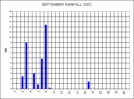
SEPTEMBER
The settled spell that ended August continued into the first 2 days of the month. There was near drought conditions with only 5MM of rainfall falling from the 10th August to the 3rd September. Low pressure moved up from France on the 4th to bring 9MM on the day. Pressure was low from the 5th to the 10th with fronts moving in from the southwest. The 8th saw a clear start to the day, but as the temperature climbed, clouds developed to bring a torrential downpour, giving 5.8MM in just 30 minutes. A low developed along a cold front on the 9th to bring a very wet day here at Bradninch with 12.4MM. North Devon didn’t get any rain on the 9th as the front didn’t move that far west. Under calm conditions on the 10th the minimum temperature dropped to 5.3C, a sure sign of the Autumn coming. The 13th saw a return to the Summer, with clear blue skies and a maximum for the day of 24.1C. High pressure over Scandinavia dominated our weather from the 11th to the 30th bringing a lot of dry, sunny, settled weather. Only 1.6MM fell from the 11th to the 30th. A very unusual dry end to September. The Crofthayes well was still at a 10 year low or since records began.
Average temperatures were:- Max 19.6C (+1.6) highest since records began, Min 9.6C (-1.2) and a mean of 14.6 (+.2). Rainfall for September was on the low side with a total of 35MM and this was minus 50.4MM below the average.
OCTOBER
The 1st to the 3rd saw showery rain move across the country, but this welcomed rain was temporary as high pressure built again from the Azores. A glorious day on the 5th with clear blue skies and a high for the day of 19.7C this made it feel like a summer’s day. This high only slowly moved away to the north east from the 7th to the 11th, after which the massive breakdown started. By the 11th October the ground was amazingly dry for the time of the year, I can’t remember the ground being so dry, so late in the year before. There was 61 dry days from the 17th July to the 11th October, during this period only 81.2MM fell. This dry spell came to an abrupt end on Sunday 13th as a major low moved up from the south west. Sixteen hours of continuous, heavy, driving rain gave an amazing total of 52.4MM making this the wettest DAY since my records began. August 1997 held the previous wet day with 52mm (see chart below). A lull in the weather on the 14th with mostly calm conditions but this didn’t last. Another deepening low tracked along the same path of the previous one to bring another very wet day on the 15th. From 3 to 10 a.m. we had 28MM, and a further 9MM fell during the rest of the day, 7MM of which fell in just a 15 minute period around midday. So the 15th saw 37MM falling making this the 4th wettest day since records began. We had more rain on the 13th and 15th (89MM) than all the period 17th July to the 11th October (91 days = 81.2MM) put together. Luckily the ground was so dry before the rains arrived, and this helped soak up the rainfall, therefore river flooding didn’t happen. It would have been a different story if we had these totals in December. The saying: ‘Be it dry or be it wet - The weather always pays it debts’ was certainly true this time. This wet spell has certainly made up for all the dry weather we have had since July. Before moving on I must just mention the mini tornado that affected a very small area of Torquay on the 15th. Here in the south west there are around 5 - 10 reported Tornado’s, waterspouts and funnel clouds, most never get in contact with the ground. The Torquay Tornado would have been an F0 (out of scale to f5), possible touching F1 with winds from 40 - 72mph. From the 16th it turned much cooler as the winds switched to a northerly. The first ground frost came on the 18th and unusually the first air frost came on the 19th with a low of minus 2.9C. This was the lowest temperature for the first air frost of the Autumn since my records began. The 19th was a cool, mostly sunny day ahead of the 3>rd in the series of deep lows to move up from the south west on the 21st. The reason for all the heavy rains are that the lows are coming across the warmer waters of the Atlantic (sea’s are at their warmest in October) and have lots of energy associated with them. The reason they are tracking up from the south west is because of a blocking high affecting Greenland, therefore moving the Jet Stream further southwards. The weather remained unsettled to the end of the month.
Average temperatures were:- Max 14.9C (+1) , Min 7.3C (-.4) and a mean of 11.1 (+.3). Rainfall was high with a total of 149.4MM and this was + 55.6MM above the average.
NOVEMBER
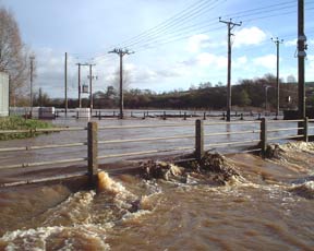
The very disturbed weather continued into November with low after low affecting the country off the Atlantic. The 1st saw a very moist southwesterly flow as we were in between a warm and cold front this gave a daytime humidity of 92% making this one of the highest of the year. A deepening low moved in from the 2nd to bring 14.2MM on a dull, cloudy day. The 4th and 5th> saw slightly drier weather as a ridge of high pressure moved east. This high soon got pushed out of the way by an active front on the 6th to bring 19.4MM on the day. The 11th to the 15th saw an Atlantic low of some 1000 miles (1609km) in diameter dominate our weather with fronts circulating around it and this brought a week of very bad weather. During the evening of the 13th another low moving into our area from the south and this brought 30MM during an 8 hour period ending at 2am on the 14th. By 1am on the 14th nearly every road in the mid Devon area got flooded and many became impassable. Both the New A30 and the old A30, the A396 to Tiverton and the B3181 to Cullompton got closed by the shear volume of water running off the fields. The River Culm responded very quickly as the ground was already waterlogged by previous rains. By 11am on the 14th the Culm was about 18 inches over the road at Hele making this the highest level for 20 years. The railway was under about 6 inches for about 40 meters either side of the crossing and remained closed for most of the day. Unfortunately properties got flooded again with Crossways Tavern and Lease cottage badly affected. Have a look at my website for photos of the flooding (address at top of page). The week ending on Sunday the 17th saw a total of 58.2MM falling. It remained very unsettled to the end of the month but unusually there was no frosts.A MONTH OF MANY RECORDS BEING BROKEN
With a south westerly flow all month dominated by 3 major lows in the Atlantic this has kept us under very mild weather. There has only been 2 ground frosts all month. It has turned out to be the mildest November on record. Rainfall has also broken records with November this year having the wettest conditions since records began. Well levels have shot up this month with both wells at record highs for November.Average temperatures were well above the average with :- Max 12.7C (+2.2) , Min 7C (+1.8) and a mean of 9.9 (+2.1). Rainfall was very high with a total of 191.8MM and this was + 88.8MM above the average.
WHY ARE WE HAVING MORE FLOODING LATELY?
From 1960 to 1999 the river Culm came over the road at Hele only twice, so why has it been over the road 3 times in the last 2 years? I personally feel that there are 3 reasons for this and they are as follows. (1) All the last 3 floods have been with a warm, very moist southwesterly flow, and therefore the fronts have more energy and produce more rain. (2) Global warming is also having some effect as October’s do seem to be warmer than they were some 20+ years ago. (3) The 3rd and what I think is the main reason is the hundreds and hundreds of houses with their associated roads that have been built up the Culm valley in the last 5 years. This has put an enormous pressure on the river from the run-off from the roofs and roads that would have normally just soaked into the ground if there was just fields. With even more houses going up, flooding will be an ongoing problem at the lower end of the river Culm
Click here for photos of the flooding at Hele on the 14th November, 2002

AUTUMN
September was a very dry month with only 35MM falling. This dry spell came to an end as we experienced a very wet October and November. November was a month dominated by low pressure coming off the Atlantic and due to this direction the Autumn was fairly mild. As mentioned above the river Culm was at its highest level for 20 years on the 14th of November.
To sum up the Autumn it would be:- WET AND MILD
RAINFALL WAS 376.2MM (+93.9MM FROM AVERAGE) MAKING THIS THE WETTEST AUTUMN ON RECORD.
Temperatures were: Max 15.7C (+1.6C), Min 7.9C (0.0) an the mean was 11.8C (+.8)
DECEMBER
Atlantic fronts dominated the first 4 days of the month but then there was a major change as high pressure from the northeast moved in. This brought a drop in the temperature and with a high wind chill of -15C by the 10th. An occluded font moved up from France on the 10th and as this moved into the cold air the rain turned to snow. There was a light covering of snow during the afternoon of the 10th with a daytime high of only 2.3C. Fronts continued to move northwards up across the country to the 14th. High pressure built again from the north on the 15th to the 19th bringing more chilly winds from the east.
From the 20th to the end of the month we had Atlantis weather systems moving across the country and it became very mild with a high of 13.1C on the 24th. Humidity on the 21st did not drop below 96% all day and this was an all time record. The month ended on a very mild theme.
THERE WAS NO AIR FROSTS ALL MONTH - ANOTHER RECORD BROKEN
OVERALL THE MONTH WAS SPLIT IN 3 WITH MILD START THEN COLD SPELL ENDING IN A VERY MILD SPELL
Average temperatures were above the average with :- Max 8.6C (+.6) , Min 4.8C (+1.7) and a mean of 6.7 (+1.1). Rainfall was slightly below average with a total of 93.6MM and this was -12.7MM below the average.
7 months had above average rainfall with the highest total during November with 191.8MM, this very wet November caused severe flooding again in the mid-Devon area.
October the 13th saw the wettest since my records began with 52.8MM falling.
5 months had below average rainfall with the lowest total coming during June with 29.2MM.
Well level at Crofthayes was at a record high in May then Record low levels from June to October then it shot up to the highest November level since records began - a strange year for the levels. Click here to view chart.
The main thunderstorm event of the year was on
the 17th May
Click here or on
photo to take you to see all the photos from this storm.
9 months had above average mean temperatures.
From October to December we only had 2 air frosts and this was a record as we usually get a least 10 - 15 during this time.
Due to the mild end of the year many shrubs held their leaves until Xmas like the Wisteria and Fuchsias. Never before can I remember so many flowers and leaves still on shrubs.
ANOTHER YEAR OF EVER CHANGING SEASONS
Average temperatures were around the average with :- Max 14.9C (+.6) , Min 7.3C (+.1) and a mean of 11.1 (+.3). It was the wettest year since 1998 with a total of 1030MM and this was +117.9MM above the average.